Deck 3: Spatial Data Input and Manipulation
Full screen (f)
Question
Question
Question
Question
Question
Question
Question
Question
Question
Question
Question
Question
Question
Question
Question
Question
Question
With the classification error matrix below, what is the overall accuracy of the land use classification?
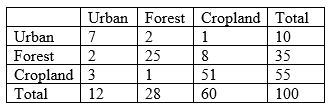
A) 100%
B) 27.7%
C) 29%
D) 83%
A) 100%
B) 27.7%
C) 29%
D) 83%
Question
Question
Question
Question
Question

Unlock Deck
Sign up to unlock the cards in this deck!
Unlock Deck
Unlock Deck
1/22
Play
Full screen (f)
Deck 3: Spatial Data Input and Manipulation
1
Digitising is the process of
A) entering the coordinates of a number of point features into a GIS via keyboard
B) converting paper maps or images to digital vector data
C) capturing vector data using GPS
D) collecting vector data through crowdsourcing
A) entering the coordinates of a number of point features into a GIS via keyboard
B) converting paper maps or images to digital vector data
C) capturing vector data using GPS
D) collecting vector data through crowdsourcing
B
2
To digitise a paper map, one first needs to establish control points. The control points may be
A) road intersections
B) points on soil boundaries
C) points on contour lines
D) centre points of water bodies
E) all of the above
A) road intersections
B) points on soil boundaries
C) points on contour lines
D) centre points of water bodies
E) all of the above
A
3
The accuracy of vector data captured through digitising is independent of
A) the number of the points selected to approximate the shape of the features
B) the number of the geographical features selected to digitise from the original map
C) the density of the points selected to approximate the shape of the features
D) the accuracy of the individual points selected to approximate the shape of the features
E) the accuracy of the original map
B
4
Georeferencing an image in GIS involves
A) selecting at least three control points
B) mathematically establishing linear or non-linear relationships between image coordinates and real-world coordinates
C) transforming the image so that each location on the image can be defined in real-world coordinates
D) all of the above
A) selecting at least three control points
B) mathematically establishing linear or non-linear relationships between image coordinates and real-world coordinates
C) transforming the image so that each location on the image can be defined in real-world coordinates
D) all of the above
Unlock Deck
Unlock for access to all 22 flashcards in this deck.
Unlock Deck
k this deck
5
Raster data can be captured
A) by means of remote sensing
B) by means of GNSS
C) through on-screen digitising
D) through tablet digitising
A) by means of remote sensing
B) by means of GNSS
C) through on-screen digitising
D) through tablet digitising
Unlock Deck
Unlock for access to all 22 flashcards in this deck.
Unlock Deck
k this deck
6
Which of the following is correct?
A) Direct transfer of spatial data allows the data to be edited.
B) Direct transfer of spatial data is the main means of importing data with complex data formats.
C) Direct transfer of spatial data allows the non-native data to be translated on the fly.
D) Direct transfer of spatial data does not allow the non-native data to be translated on the fly.
Unlock Deck
Unlock for access to all 22 flashcards in this deck.
Unlock Deck
k this deck
7
Vectorisation may
A) increase the thickness of line features
B) change the orientation of features
C) alter the attribute values of features
D) distort the shapes of features
A) increase the thickness of line features
B) change the orientation of features
C) alter the attribute values of features
D) distort the shapes of features
Unlock Deck
Unlock for access to all 22 flashcards in this deck.
Unlock Deck
k this deck
8
Rubber sheeting
A) reproduces a map on a rubber sheet
B) mathematically stretches one map layer along a specific direction
C) mathematically stretches one map layer in all directions in order to enlarge it
D) geometrically adjusts map features to force a data layer to fit a base map
A) reproduces a map on a rubber sheet
B) mathematically stretches one map layer along a specific direction
C) mathematically stretches one map layer in all directions in order to enlarge it
D) geometrically adjusts map features to force a data layer to fit a base map
Unlock Deck
Unlock for access to all 22 flashcards in this deck.
Unlock Deck
k this deck
9
An affine transformation requires a minimum of
A) 3 control points
B) 6 control points
C) 9 control points
D) 10 control points
A) 3 control points
B) 6 control points
C) 9 control points
D) 10 control points
Unlock Deck
Unlock for access to all 22 flashcards in this deck.
Unlock Deck
k this deck
10
Spatial data accuracy refers to
A) how close the spatial data are to a true representation of reality
B) how much detail the spatial data contain about the geographical features
C) how much bias is contained in the spatial data
D) what level of detail at which the spatial data are recorded
A) how close the spatial data are to a true representation of reality
B) how much detail the spatial data contain about the geographical features
C) how much bias is contained in the spatial data
D) what level of detail at which the spatial data are recorded
Unlock Deck
Unlock for access to all 22 flashcards in this deck.
Unlock Deck
k this deck
11
Spatial data precision refers to
A) how close the spatial data are to a true representation of reality
B) how much detail the spatial data contain about the geographical features
C) how much bias is contained in the spatial data
D) what level of detail at which the spatial data are recorded
A) how close the spatial data are to a true representation of reality
B) how much detail the spatial data contain about the geographical features
C) how much bias is contained in the spatial data
D) what level of detail at which the spatial data are recorded
Unlock Deck
Unlock for access to all 22 flashcards in this deck.
Unlock Deck
k this deck
12
High accuracy implies high precision and vice versa
Unlock Deck
Unlock for access to all 22 flashcards in this deck.
Unlock Deck
k this deck
13
The positional accuracy of a point feature is associated with
A) errors in its recorded x coordinate
B) errors in its recorded y coordinate
C) errors in its recorded z coordinate
D) all the above
A) errors in its recorded x coordinate
B) errors in its recorded y coordinate
C) errors in its recorded z coordinate
D) all the above
Unlock Deck
Unlock for access to all 22 flashcards in this deck.
Unlock Deck
k this deck
14
The positional accuracy of a line feature is associated with
A) errors in the locations of the individual points selected to represent the feature
B) errors in locating well-defined points along the line feature
C) both a) and b)
D) neither a) nor b)
A) errors in the locations of the individual points selected to represent the feature
B) errors in locating well-defined points along the line feature
C) both a) and b)
D) neither a) nor b)
Unlock Deck
Unlock for access to all 22 flashcards in this deck.
Unlock Deck
k this deck
15
The accuracy of the air temperature data recorded at a number of geographically distributed meteorological stations can be assessed using
A) RMSE
B) cross-tabulation
C) standard deviation
D) mean
A) RMSE
B) cross-tabulation
C) standard deviation
D) mean
Unlock Deck
Unlock for access to all 22 flashcards in this deck.
Unlock Deck
k this deck
16
The accuracy of soil classification on a soil map can be assessed using
A) RMSE
B) cross-tabulation
C) standard deviation
D) mean
A) RMSE
B) cross-tabulation
C) standard deviation
D) mean
Unlock Deck
Unlock for access to all 22 flashcards in this deck.
Unlock Deck
k this deck
17
With the classification error matrix below, what is the overall accuracy of the land use classification?
A) 100%
B) 27.7%
C) 29%
D) 83%
A) 100%
B) 27.7%
C) 29%
D) 83%
Unlock Deck
Unlock for access to all 22 flashcards in this deck.
Unlock Deck
k this deck
18
Lineage of a spatial dataset does not describe
A) the scale of its source data
B) the date of its source data
C) the data capture and processing methods
D) the layout of its source maps
A) the scale of its source data
B) the date of its source data
C) the data capture and processing methods
D) the layout of its source maps
Unlock Deck
Unlock for access to all 22 flashcards in this deck.
Unlock Deck
k this deck
19
Manual digitising is a significant source of errors in spatial data. But which of the following is not typically an error from manual digitising?
A) undershoot and overshoot
B) spikes
C) displacement
D) incomplete areal coverage
E) knot
A) undershoot and overshoot
B) spikes
C) displacement
D) incomplete areal coverage
E) knot
Unlock Deck
Unlock for access to all 22 flashcards in this deck.
Unlock Deck
k this deck
20
Vector to raster conversion may cause loss of information because
A) small polygons could be lost
B) a point feature can only be represented using a single grid cell
C) real-world locations of geographical features can no longer be determined
D) measurement becomes inaccurate
A) small polygons could be lost
B) a point feature can only be represented using a single grid cell
C) real-world locations of geographical features can no longer be determined
D) measurement becomes inaccurate
Unlock Deck
Unlock for access to all 22 flashcards in this deck.
Unlock Deck
k this deck
21
Slivers are long and narrow polygons generated when
A) overlaying two layers with some common boundaries that were digitised separately
B) producing buffers around area features
C) digitising river banks
D) digitising long and narrow area features
A) overlaying two layers with some common boundaries that were digitised separately
B) producing buffers around area features
C) digitising river banks
D) digitising long and narrow area features
Unlock Deck
Unlock for access to all 22 flashcards in this deck.
Unlock Deck
k this deck
22
The quality of data produced from an overlay procedure is
A) as good as the best data input to the process
B) as good as the worst data input to the process
C) better than the best data input to the process
D) irrelevant to the input data
A) as good as the best data input to the process
B) as good as the worst data input to the process
C) better than the best data input to the process
D) irrelevant to the input data
Unlock Deck
Unlock for access to all 22 flashcards in this deck.
Unlock Deck
k this deck
Unlock Deck
Unlock for access to all 22 flashcards in this deck.


