Deck 12: Weather Analysis and Forecasting
Full screen (f)
Question
Question
Question
Question
Question
Question
Question
Question
Question
Question
Question
Question
Question
Question
Question
Question
Question
Question
Question

-The current sea level air pressure represented on the station model shown above is:
A) 910.5 mb.
B) 969.0 mb.
C) 1010.5 mb.
D) 1020.0 mb.
Question
Question

-What is the current wind direction represented on the station model shown above?
A) NE
B) SW
C) NW
D) SE
Question
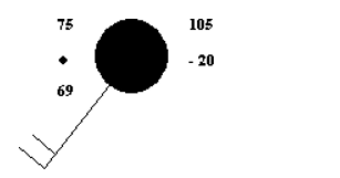
-What is the current air temperature represented on the station model shown above?
A) 69°F
B) 75°F
C) 105°F
D) 75°C
E) - 20°C
Question
Question
Question
Question
Question
Question
Question
Question
Question
Question
Question
Question
Question
Question
Question
Question
Question
Question
Question
Question
Question
Question
Question
Question
Question
Question
Question
Question
Question
Question
Question
Question
Question
Question
Question
Question
Question
Question

-What is the dew point represented on the station model shown above?
A) 75°F
B) - 20°C
C) 69°F
D) 69°C
Question
Question
Question
Question
Question
Question
Question
Question
Question
Question
Question
Question
Question
Question
Question
Question
Question
Question
Question
Question

Unlock Deck
Sign up to unlock the cards in this deck!
Unlock Deck
Unlock Deck
1/103
Play
Full screen (f)
Deck 12: Weather Analysis and Forecasting
1
Synoptic charts have isobars plotted at ________ millibar intervals.
A) 5
B) 1
C) 12
D) 10
E) 4
A) 5
B) 1
C) 12
D) 10
E) 4
4
2
Infrared images provide a way to determine which clouds are more likely to produce what?
A) precipitation
B) drought
C) wind
D) humidity
A) precipitation
B) drought
C) wind
D) humidity
A
3
The Storm Prediction Center in Norman, Oklahoma, maintains a constant vigil for:
A) floods and flash floods.
B) thunderstorms and tornadoes.
C) snow storms.
D) hurricanes and tropical storms.
A) floods and flash floods.
B) thunderstorms and tornadoes.
C) snow storms.
D) hurricanes and tropical storms.
B
4
Which of the following data are not plotted on a weather chart?
A) dew- point temperature
B) solar radiation
C) sky cover
D) cloud height
E) temperature
A) dew- point temperature
B) solar radiation
C) sky cover
D) cloud height
E) temperature
Unlock Deck
Unlock for access to all 103 flashcards in this deck.
Unlock Deck
k this deck
5
Your local weather forecast is most likely provided by the (a):
A) National Hurricane Center.
B) National Meteorological Center.
C) National Severe Storm Forecast Center.
D) Weather Forecast Office.
A) National Hurricane Center.
B) National Meteorological Center.
C) National Severe Storm Forecast Center.
D) Weather Forecast Office.
Unlock Deck
Unlock for access to all 103 flashcards in this deck.
Unlock Deck
k this deck
6
The process of predicting the future state of the atmosphere is called:
A) weather forecasting.
B) weather analysis.
C) weather predicting.
D) hindcasting.
A) weather forecasting.
B) weather analysis.
C) weather predicting.
D) hindcasting.
Unlock Deck
Unlock for access to all 103 flashcards in this deck.
Unlock Deck
k this deck
7
When the upper- air exhibits a general _______flow, cyclonic systems tend to move through quickly, creating rapidly changing weather conditions.
A) West to South
B) West to East
C) North to South
D) North to East
A) West to South
B) West to East
C) North to South
D) North to East
Unlock Deck
Unlock for access to all 103 flashcards in this deck.
Unlock Deck
k this deck
8
____________predict(s) that future weather will be the same as the present weather conditions.
A) Nowcasting
B) Persistence forecasts
C) Trend forecasting
D) The analog method
A) Nowcasting
B) Persistence forecasts
C) Trend forecasting
D) The analog method
Unlock Deck
Unlock for access to all 103 flashcards in this deck.
Unlock Deck
k this deck
9
Long range forecasts (monthly or seasonal) include predictions of:
A) precipitation.
B) temperature.
C) pressure.
D) wind.
E) temperature and precipitation.
A) precipitation.
B) temperature.
C) pressure.
D) wind.
E) temperature and precipitation.
Unlock Deck
Unlock for access to all 103 flashcards in this deck.
Unlock Deck
k this deck
10
The winds at the____________level are the steering mechanism for air mass thunderstorms.
A) 300- mb
B) 700- mb
C) 500- mb
D) 850- mb
A) 300- mb
B) 700- mb
C) 500- mb
D) 850- mb
Unlock Deck
Unlock for access to all 103 flashcards in this deck.
Unlock Deck
k this deck
11
An ensemble forecast is produced by:
A) slightly altering the underlying assumptions of a numerical model each time it is run.
B) collecting the professional opinions of a group of meteorologists.
C) combining the results from several different numerical models into one forecast.
D) running one model several times with slightly different initial conditions.
Unlock Deck
Unlock for access to all 103 flashcards in this deck.
Unlock Deck
k this deck
12
A farmer is trying to determine which kind of seed he should plant. He consults a(n) in order to determine the length of his growing season and average rainfall in order to make the best choice.
A) climatological forecast
B) analog forecast
C) numerical forecast
D) persistence forecast
A) climatological forecast
B) analog forecast
C) numerical forecast
D) persistence forecast
Unlock Deck
Unlock for access to all 103 flashcards in this deck.
Unlock Deck
k this deck
13
The primary purpose of a radiosonde is:
A) to acquire data about conditions in the upper atmosphere.
B) to compile data from thousands of automated weather stations into one file.
C) to report data about surface conditions at an automated weather station.
D) to calculate numerical predictions of weather.
A) to acquire data about conditions in the upper atmosphere.
B) to compile data from thousands of automated weather stations into one file.
C) to report data about surface conditions at an automated weather station.
D) to calculate numerical predictions of weather.
Unlock Deck
Unlock for access to all 103 flashcards in this deck.
Unlock Deck
k this deck
14
The forecasts for local and regional weather are produced by:
A) National Cyclone Center.
B) Weather Forecast Offices.
C) National Centers for Environmental Prediction.
D) State Weather Forecast Offices.
A) National Cyclone Center.
B) Weather Forecast Offices.
C) National Centers for Environmental Prediction.
D) State Weather Forecast Offices.
Unlock Deck
Unlock for access to all 103 flashcards in this deck.
Unlock Deck
k this deck
15
The current conditions in your location are sunny with a temperature of 85°F. Based on these observations, you forecast that in a few hours, it will be sunny with a temperature in the mid 80s. What kind of forecast have you issued?
A) a statistical forecast
B) a numerical forecast
C) a persistence forecast
D) an analog forecast
A) a statistical forecast
B) a numerical forecast
C) a persistence forecast
D) an analog forecast
Unlock Deck
Unlock for access to all 103 flashcards in this deck.
Unlock Deck
k this deck
16
How can a satellite "see" water vapor in the atmosphere?
A) It measures solar radiation reflecting off of the water vapor.
B) It estimates vapor based on the temperature of the atmosphere.
C) The satellite is capable of sensing the wavelength of radiation typically emitted by water vapor.
D) It can't see vapor - it can only identify places where vapor is condensing.
Unlock Deck
Unlock for access to all 103 flashcards in this deck.
Unlock Deck
k this deck
17
The development of large, fast computers has allowed this method of weather prediction to become useful.
A) analog
B) numerical
C) persistence
D) nowcasting
A) analog
B) numerical
C) persistence
D) nowcasting
Unlock Deck
Unlock for access to all 103 flashcards in this deck.
Unlock Deck
k this deck
18
The multi- screened computer system used by a weather forecaster to review data and make a forecast is called:
A) The Ensemble Forecast System (TEFS)
B) Advanced Weather Interactive Processing System (AWIPS)
C) Geographic Organization Electronic System (GOES)
D) The SkewT System
A) The Ensemble Forecast System (TEFS)
B) Advanced Weather Interactive Processing System (AWIPS)
C) Geographic Organization Electronic System (GOES)
D) The SkewT System
Unlock Deck
Unlock for access to all 103 flashcards in this deck.
Unlock Deck
k this deck
19
-The current sea level air pressure represented on the station model shown above is:
A) 910.5 mb.
B) 969.0 mb.
C) 1010.5 mb.
D) 1020.0 mb.
Unlock Deck
Unlock for access to all 103 flashcards in this deck.
Unlock Deck
k this deck
20
Successful short term forecasts (a few hours) can often be made using this method of prediction.
A) probability forecasting
B) analog forecasting
C) climatological forecasting
D) upper- wave forecasting
E) persistence forecasting
A) probability forecasting
B) analog forecasting
C) climatological forecasting
D) upper- wave forecasting
E) persistence forecasting
Unlock Deck
Unlock for access to all 103 flashcards in this deck.
Unlock Deck
k this deck
21
-What is the current wind direction represented on the station model shown above?
A) NE
B) SW
C) NW
D) SE
Unlock Deck
Unlock for access to all 103 flashcards in this deck.
Unlock Deck
k this deck
22
-What is the current air temperature represented on the station model shown above?
A) 69°F
B) 75°F
C) 105°F
D) 75°C
E) - 20°C
Unlock Deck
Unlock for access to all 103 flashcards in this deck.
Unlock Deck
k this deck
23
These satellites were placed in orbit over the equator and remain fixed over a point on Earth because they keep pace with the earth's rate of rotation.
A) geostationary satellites
B) Automated Surface Observing Systems
C) polar satellites
D) Doppler satellites
A) geostationary satellites
B) Automated Surface Observing Systems
C) polar satellites
D) Doppler satellites
Unlock Deck
Unlock for access to all 103 flashcards in this deck.
Unlock Deck
k this deck
24
If you have taken a sounding, what have you done?
A) collected radiosonde data
B) downloaded data from an ASOS
C) used a wind profiler
D) analyzed a storm with a Doppler radar
A) collected radiosonde data
B) downloaded data from an ASOS
C) used a wind profiler
D) analyzed a storm with a Doppler radar
Unlock Deck
Unlock for access to all 103 flashcards in this deck.
Unlock Deck
k this deck
25
These types of images are views of the earth the way an astronaut would see our planet from space.
A) Moon images
B) water vapor images
C) infrared images
D) visible images
A) Moon images
B) water vapor images
C) infrared images
D) visible images
Unlock Deck
Unlock for access to all 103 flashcards in this deck.
Unlock Deck
k this deck
26
In order to make a forecast, the meteorologist must:
A) run two models and calculate the average of the two predictions.
B) retrieve the model's results from NCEP and pass the exact results along to the public.
C) decide which model (s)he prefers and stick to it exclusively.
D) compare two models and factor in the biases and limitations that each model has.
Unlock Deck
Unlock for access to all 103 flashcards in this deck.
Unlock Deck
k this deck
27
Why is the pattern of upper- level winds an important part of the forecasting process?
A) Surface pressure controls the wind aloft.
B) Jet streams aloft always lead to storms.
C) Rainfall at the surface corresponds to westerly flow aloft.
D) It strongly influences the development of surface storms.
A) Surface pressure controls the wind aloft.
B) Jet streams aloft always lead to storms.
C) Rainfall at the surface corresponds to westerly flow aloft.
D) It strongly influences the development of surface storms.
Unlock Deck
Unlock for access to all 103 flashcards in this deck.
Unlock Deck
k this deck
28
On a surface- level synoptic weather chart, a front is often identified by zones that exhibit:
A) gradual changes in pressure.
B) a strong jet stream.
C) abrupt changes in temperature, humidity, and wind direction.
D) clear skies.
A) gradual changes in pressure.
B) a strong jet stream.
C) abrupt changes in temperature, humidity, and wind direction.
D) clear skies.
Unlock Deck
Unlock for access to all 103 flashcards in this deck.
Unlock Deck
k this deck
29
Synoptic weather maps display weather data that:
A) were measured at the same place.
B) show multiple levels of the atmosphere on the same chart.
C) were measured at the same time.
D) were measured by a satellite.
E) were calculated by a mathematical model.
A) were measured at the same place.
B) show multiple levels of the atmosphere on the same chart.
C) were measured at the same time.
D) were measured by a satellite.
E) were calculated by a mathematical model.
Unlock Deck
Unlock for access to all 103 flashcards in this deck.
Unlock Deck
k this deck
30
Airflow aloft is often illustrated with_____________ , lines of equal wind speed.
A) isometers
B) isotachs
C) isobars
D) isovels
A) isometers
B) isotachs
C) isobars
D) isovels
Unlock Deck
Unlock for access to all 103 flashcards in this deck.
Unlock Deck
k this deck
31
The acronym NOAA stands for:
A) Numerical Observation Assessment Association.
B) National Oceanic and Atmospheric Administration.
C) National Observatory for Atmospheric Assessment.
D) Nightly Observation of Atmospheric Attributes.
A) Numerical Observation Assessment Association.
B) National Oceanic and Atmospheric Administration.
C) National Observatory for Atmospheric Assessment.
D) Nightly Observation of Atmospheric Attributes.
Unlock Deck
Unlock for access to all 103 flashcards in this deck.
Unlock Deck
k this deck
32
Which technique is used that attempts to match current conditions with similar well established patterns from the past?
A) analog method
B) isotachs method
C) trend forecasting
D) persistence forecasting
A) analog method
B) isotachs method
C) trend forecasting
D) persistence forecasting
Unlock Deck
Unlock for access to all 103 flashcards in this deck.
Unlock Deck
k this deck
33
The word synoptic literally means:
A) related to weather.
B) coincident in time.
C) bird- eyed.
D) of the same place.
A) related to weather.
B) coincident in time.
C) bird- eyed.
D) of the same place.
Unlock Deck
Unlock for access to all 103 flashcards in this deck.
Unlock Deck
k this deck
34
Which of the following rely on the fact that gases of the atmosphere obey a number of known physical principles to predict the future state of the atmosphere?
A) statistical methods
B) trend forecasting
C) numerical weather prediction
D) persistence forecasting
A) statistical methods
B) trend forecasting
C) numerical weather prediction
D) persistence forecasting
Unlock Deck
Unlock for access to all 103 flashcards in this deck.
Unlock Deck
k this deck
35
The path that Northern Hemisphere cyclonic storms follow (storm track) is usually farther to the south during:
A) summer.
B) nighttime.
C) autumn.
D) winter.
A) summer.
B) nighttime.
C) autumn.
D) winter.
Unlock Deck
Unlock for access to all 103 flashcards in this deck.
Unlock Deck
k this deck
36
When completing a forecast, what does a very low lifted index tell you?
A) That the atmosphere is very unstable.
B) That rising air is not likely to reach the lifting condensation level (LCL).
C) That severe weather events are not likely to develop.
D) That the atmosphere is absolutely stable.
A) That the atmosphere is very unstable.
B) That rising air is not likely to reach the lifting condensation level (LCL).
C) That severe weather events are not likely to develop.
D) That the atmosphere is absolutely stable.
Unlock Deck
Unlock for access to all 103 flashcards in this deck.
Unlock Deck
k this deck
37
What is a typical time- step for a numerical weather model?
A) 30 minutes
B) 5 minutes
C) 1 hour
D) 30 seconds
A) 30 minutes
B) 5 minutes
C) 1 hour
D) 30 seconds
Unlock Deck
Unlock for access to all 103 flashcards in this deck.
Unlock Deck
k this deck
38
Upper- air maps are commonly drawn for all the following pressures, EXCEPT:
A) 700 millibars.
B) 200 millibars.
C) 500 millibars.
D) 850 millibars.
E) 1000 millibars.
A) 700 millibars.
B) 200 millibars.
C) 500 millibars.
D) 850 millibars.
E) 1000 millibars.
Unlock Deck
Unlock for access to all 103 flashcards in this deck.
Unlock Deck
k this deck
39
One commonly used way to improve a numerical model forecast is to:
A) simplify the model's assumptions.
B) eliminate portions of the model that aren't contributing to the forecast.
C) statistically assess errors that the model makes repeatedly and adjust the forecast accordingly.
D) reformulate the model after every forecast to correct errors.
A) simplify the model's assumptions.
B) eliminate portions of the model that aren't contributing to the forecast.
C) statistically assess errors that the model makes repeatedly and adjust the forecast accordingly.
D) reformulate the model after every forecast to correct errors.
Unlock Deck
Unlock for access to all 103 flashcards in this deck.
Unlock Deck
k this deck
40
Why are some satellites described as being stationary?
A) They can only observe stationary weather systems.
B) They have no orbital motion.
C) Their orbital motion matches the earth's rotation and stay above the same site.
D) They orbit over the earth's poles.
A) They can only observe stationary weather systems.
B) They have no orbital motion.
C) Their orbital motion matches the earth's rotation and stay above the same site.
D) They orbit over the earth's poles.
Unlock Deck
Unlock for access to all 103 flashcards in this deck.
Unlock Deck
k this deck
41
In the United States, the governmental agency responsible for gathering and disseminating weather- related information is the:
A) American Weather Association.
B) National Atmosphere Association.
C) American Meteorological Service.
D) National Weather Service.
A) American Weather Association.
B) National Atmosphere Association.
C) American Meteorological Service.
D) National Weather Service.
Unlock Deck
Unlock for access to all 103 flashcards in this deck.
Unlock Deck
k this deck
42
What is deep atmospheric convection?
A) Convection that is buried under a thick capping inversion layer.
B) Convection that does not begin until a very great height above the surface.
C) Convection that extends over a large geographic region.
D) Convection that begins near the ground and extends to the tropopause.
A) Convection that is buried under a thick capping inversion layer.
B) Convection that does not begin until a very great height above the surface.
C) Convection that extends over a large geographic region.
D) Convection that begins near the ground and extends to the tropopause.
Unlock Deck
Unlock for access to all 103 flashcards in this deck.
Unlock Deck
k this deck
43
The accuracy of day- to- day weather forecasts for periods beyond__________ day(s) is relatively unreliable.
A) 1
B) 3
C) 5
D) 7
A) 1
B) 3
C) 5
D) 7
Unlock Deck
Unlock for access to all 103 flashcards in this deck.
Unlock Deck
k this deck
44
A prognostic chart:
A) is used to pinpoint the current location of fronts.
B) displays numerical forecasts for future conditions in precipitation, wind speed, and upper air flow.
C) is used to explain the causes of thunderstorms as they are happening.
D) evaluates past weather conditions to predict future ones.
A) is used to pinpoint the current location of fronts.
B) displays numerical forecasts for future conditions in precipitation, wind speed, and upper air flow.
C) is used to explain the causes of thunderstorms as they are happening.
D) evaluates past weather conditions to predict future ones.
Unlock Deck
Unlock for access to all 103 flashcards in this deck.
Unlock Deck
k this deck
45
Why are most weather data displayed in the form of a map or chart?
A) Maps are easier to construct than tables.
B) Maps display the data in their proper place, relative to other data, and allow the identification of patterns.
C) Maps are easier to remember.
D) More data can be recorded on a map.
A) Maps are easier to construct than tables.
B) Maps display the data in their proper place, relative to other data, and allow the identification of patterns.
C) Maps are easier to remember.
D) More data can be recorded on a map.
Unlock Deck
Unlock for access to all 103 flashcards in this deck.
Unlock Deck
k this deck
46
Meteorology entered the space age on April 1,_________ , when the first weather satellite was launched into space.
A) 1920
B) 1980
C) 1945
D) 1960
A) 1920
B) 1980
C) 1945
D) 1960
Unlock Deck
Unlock for access to all 103 flashcards in this deck.
Unlock Deck
k this deck
47
When upper- air flow produces large- amplitude troughs and a general _________flow, cold air moves southward and cyclonic activity dominates the weather. (Assume Northern Hemisphere.)
A) West to East
B) West to South
C) North to East
D) North to South
A) West to East
B) West to South
C) North to East
D) North to South
Unlock Deck
Unlock for access to all 103 flashcards in this deck.
Unlock Deck
k this deck
48
________weather forecasting is an area that relies heavily on statistical averages obtained from past weather events (climatic data).
A) Long range
B) Ensemble
C) Numerical
D) Persistence
A) Long range
B) Ensemble
C) Numerical
D) Persistence
Unlock Deck
Unlock for access to all 103 flashcards in this deck.
Unlock Deck
k this deck
49
Which of the following upper air maps is most useful for observing the details of the polar jet stream?
A) 500- mb map
B) 1000- mb map
C) 850- mb map
D) 300- mb map
A) 500- mb map
B) 1000- mb map
C) 850- mb map
D) 300- mb map
Unlock Deck
Unlock for access to all 103 flashcards in this deck.
Unlock Deck
k this deck
50
A wave pattern in the upper- level winds at middle latitudes in the Northern Hemisphere provides for:
A) colder temperatures at all latitudes.
B) cold air moving south.
C) decreased snowfall.
D) warm air moving south.
A) colder temperatures at all latitudes.
B) cold air moving south.
C) decreased snowfall.
D) warm air moving south.
Unlock Deck
Unlock for access to all 103 flashcards in this deck.
Unlock Deck
k this deck
51
A set of station models on a surface weather map that reveal a sharp wind shift across a short distance and a marked changed in temperature and humidity indicate the presence of:
A) a uniform air mass.
B) a front.
C) a thunderstorm.
D) a geostrophic wind.
A) a uniform air mass.
B) a front.
C) a thunderstorm.
D) a geostrophic wind.
Unlock Deck
Unlock for access to all 103 flashcards in this deck.
Unlock Deck
k this deck
52
If you need to measure wind speed and direction at a height of 10 km above the surface, the type of radar you would use is called:
A) a tropospheric assessor.
B) Doppler radar.
C) a wind profiler.
D) sonic radar.
A) a tropospheric assessor.
B) Doppler radar.
C) a wind profiler.
D) sonic radar.
Unlock Deck
Unlock for access to all 103 flashcards in this deck.
Unlock Deck
k this deck
53
Weather analysis includes all of the following EXCEPT:
A) collecting data.
B) compiling data.
C) prediction of future weather data.
D) plotting numerical data.
E) transmitting data.
A) collecting data.
B) compiling data.
C) prediction of future weather data.
D) plotting numerical data.
E) transmitting data.
Unlock Deck
Unlock for access to all 103 flashcards in this deck.
Unlock Deck
k this deck
54
You'd like to plan a Christmas day flight to visit family. You have several months lead time. How might you determine the probability of snowfall occurring and potentially interfering with your travel plans?
A) Consult a climatological forecast.
B) Roll the dice - no one can forecast that.
C) Refer to the analog forecast published by the NWS.
D) Watch the Weather Channel to hear the latest numerical forecast.
A) Consult a climatological forecast.
B) Roll the dice - no one can forecast that.
C) Refer to the analog forecast published by the NWS.
D) Watch the Weather Channel to hear the latest numerical forecast.
Unlock Deck
Unlock for access to all 103 flashcards in this deck.
Unlock Deck
k this deck
55
In determining the occurrence of precipitation, the NWS forecasts are correct more than_______ percent of the time.
A) 80
B) 30
C) 50
D) 10
A) 80
B) 30
C) 50
D) 10
Unlock Deck
Unlock for access to all 103 flashcards in this deck.
Unlock Deck
k this deck
56
What is a Skew- T?
A) A numerical forecast model used to predict temperature.
B) A thermodynamic diagram that helps forecasters assess atmospheric instability.
C) A computer system used by forecasters.
D) A map of forecasted temperatures.
A) A numerical forecast model used to predict temperature.
B) A thermodynamic diagram that helps forecasters assess atmospheric instability.
C) A computer system used by forecasters.
D) A map of forecasted temperatures.
Unlock Deck
Unlock for access to all 103 flashcards in this deck.
Unlock Deck
k this deck
57
Nowcasting:
A) makes little use of numerical data.
B) is primarily used for making long- range forecasts for large regions.
C) is not very useful for predicting thunderstorms and tornadoes.
D) makes extensive use of radar and geostationary satellites.
A) makes little use of numerical data.
B) is primarily used for making long- range forecasts for large regions.
C) is not very useful for predicting thunderstorms and tornadoes.
D) makes extensive use of radar and geostationary satellites.
Unlock Deck
Unlock for access to all 103 flashcards in this deck.
Unlock Deck
k this deck
58
Which of the following is responsible for collecting and assimilating weather data from across the globe?
A) Storm Prediction Center (SPC)
B) National Weather Service Forecast Office
C) National Atmospheric and Oceanic Administration (NOAA)
D) National Centers for Environmental Prediction (NCEP)
A) Storm Prediction Center (SPC)
B) National Weather Service Forecast Office
C) National Atmospheric and Oceanic Administration (NOAA)
D) National Centers for Environmental Prediction (NCEP)
Unlock Deck
Unlock for access to all 103 flashcards in this deck.
Unlock Deck
k this deck
59
One of the primary uses for a 500- mb map is:
A) to estimate surface air temperature.
B) to determine the speed and direction of motion for a mid- latitude cyclone.
C) to predict surface wind speeds.
D) to monitor the position of the polar jet stream.
A) to estimate surface air temperature.
B) to determine the speed and direction of motion for a mid- latitude cyclone.
C) to predict surface wind speeds.
D) to monitor the position of the polar jet stream.
Unlock Deck
Unlock for access to all 103 flashcards in this deck.
Unlock Deck
k this deck
60
-What is the dew point represented on the station model shown above?
A) 75°F
B) - 20°C
C) 69°F
D) 69°C
Unlock Deck
Unlock for access to all 103 flashcards in this deck.
Unlock Deck
k this deck
61
Despite advances in computer technology, numerical weather prediction has advanced little since 1960.
Unlock Deck
Unlock for access to all 103 flashcards in this deck.
Unlock Deck
k this deck
62
Which of the following weather data are not always plotted in the same location with respect to the weather station?
A) past weather
B) pressure tendency
C) cloud type
D) wind direction
E) barometric pressure
A) past weather
B) pressure tendency
C) cloud type
D) wind direction
E) barometric pressure
Unlock Deck
Unlock for access to all 103 flashcards in this deck.
Unlock Deck
k this deck
63
Nowcasting is heavily dependent on weather radar and geostationary satellites.
Unlock Deck
Unlock for access to all 103 flashcards in this deck.
Unlock Deck
k this deck
64
Long- range forecasts predict whether it will be drier/wetter or wetter/cooler than normal.
Unlock Deck
Unlock for access to all 103 flashcards in this deck.
Unlock Deck
k this deck
65
_____________assume(s) that the weather occurring upstream will persist and move on to affect the area in its path.
A) Nowcasting
B) Persistence forecasts
C) The analog method
D) Trend forecasting
A) Nowcasting
B) Persistence forecasts
C) The analog method
D) Trend forecasting
Unlock Deck
Unlock for access to all 103 flashcards in this deck.
Unlock Deck
k this deck
66
These satellites circle the earth in a north- to- south direction, and obtain images of the entire Earth twice a day by drifting about 15 degrees westward over the earth's surface during each orbit.
A) Doppler satellites
B) Automated Surface Observing Systems
C) polar satellites
D) geostationary satellites
A) Doppler satellites
B) Automated Surface Observing Systems
C) polar satellites
D) geostationary satellites
Unlock Deck
Unlock for access to all 103 flashcards in this deck.
Unlock Deck
k this deck
67
In this process a search is made for analogous past weather records: ________.
Unlock Deck
Unlock for access to all 103 flashcards in this deck.
Unlock Deck
k this deck
68
Geostationary satellites are usually centered over one pole.
Unlock Deck
Unlock for access to all 103 flashcards in this deck.
Unlock Deck
k this deck
69
Long- range forecasting employs this method: ________.
Unlock Deck
Unlock for access to all 103 flashcards in this deck.
Unlock Deck
k this deck
70
Sharing of weather data among nations around the world is very limited.
Unlock Deck
Unlock for access to all 103 flashcards in this deck.
Unlock Deck
k this deck
71
List three characteristics that are used to identify the location of a front on a synoptic weather chart.
Unlock Deck
Unlock for access to all 103 flashcards in this deck.
Unlock Deck
k this deck
72
The gas laws are applied in this method of weather prediction:________ .
Unlock Deck
Unlock for access to all 103 flashcards in this deck.
Unlock Deck
k this deck
73
What type of image allows meteorologists to distinguish between thick cold clouds and thin warm clouds?
Unlock Deck
Unlock for access to all 103 flashcards in this deck.
Unlock Deck
k this deck
74
Observing and forecasting small, short lived weather events (such as a thunderstorm) is strongly dependent on radar.
Unlock Deck
Unlock for access to all 103 flashcards in this deck.
Unlock Deck
k this deck
75
Clouds and precipitation patterns are often clues to the position of a front.
Unlock Deck
Unlock for access to all 103 flashcards in this deck.
Unlock Deck
k this deck
76
Precipitation usually occurs___________ of a cold front and _______ of a warm front.
A) with the passage; after the passage
B) before the passage; after the passage
C) after the passage; with the passage
D) with the passage; before the passage
A) with the passage; after the passage
B) before the passage; after the passage
C) after the passage; with the passage
D) with the passage; before the passage
Unlock Deck
Unlock for access to all 103 flashcards in this deck.
Unlock Deck
k this deck
77
Wind arrows generally back (turn counterclockwise) across a frontal zone.
Unlock Deck
Unlock for access to all 103 flashcards in this deck.
Unlock Deck
k this deck
78
This type of weather forecasting uses physical models of the atmosphere: .
Unlock Deck
Unlock for access to all 103 flashcards in this deck.
Unlock Deck
k this deck
79
Satellites can only provide photographs; no measurements of properties such as temperature are possible.
Unlock Deck
Unlock for access to all 103 flashcards in this deck.
Unlock Deck
k this deck
80
A person who disseminates forecasts without being a trained meteorologist is known as:
A) a weathercaster.
B) a forecast journalist.
C) a weather analyst.
D) a broadcast meteorologist.
A) a weathercaster.
B) a forecast journalist.
C) a weather analyst.
D) a broadcast meteorologist.
Unlock Deck
Unlock for access to all 103 flashcards in this deck.
Unlock Deck
k this deck
Unlock Deck
Unlock for access to all 103 flashcards in this deck.


