Deck 11: Soil and Water Resources
Full screen (f)
Question
Question
Question
Question
Question
Question
Question
Question
Question
Question
Question
Question
Question
Question
Question
Question
Question
Question
Question
Question
Question
Question
Question
Question
Question
Question
Question
Question
Question
Question
Question
Question
Question
Question
Question
Question
Question
Question
Question
Question
Question
Question
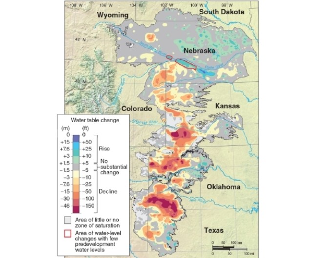
According to the map, most of the lowering of the water table level in the Ogallala Aquifer has occurred in the __________ portion(s) of the aquifer.
A)northwestern
B)northeastern
C)northeastern and central
D)central and southern
Question
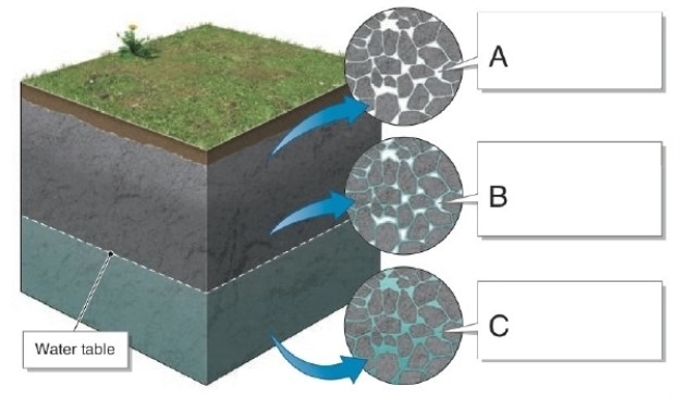
Which marked letter zone in this figure designates the zone of saturation?
A)A
B)B
C)C
D)All letters mark the zone of saturation
Question
Question
Question
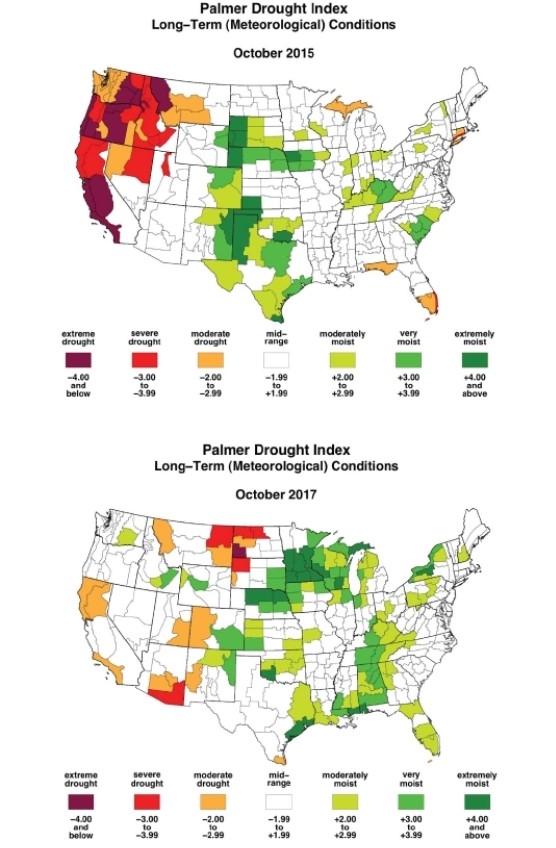
On the October 2015 map, which region shows the greatest moisture deficits?
A)the southeastern states
B)the western states
C)the Midwest
D)the East Coast
Question
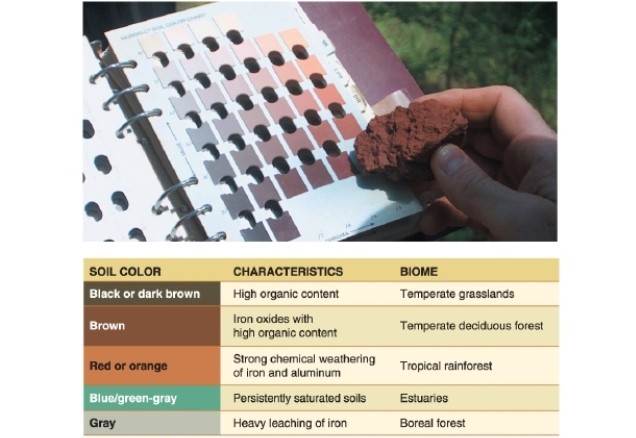
In the figure, red or orange soils indicate __________.
A)high organic content
B)strong weathering
C)persistent high water tables
D)heavy leaching of iron
Question
Question
Question
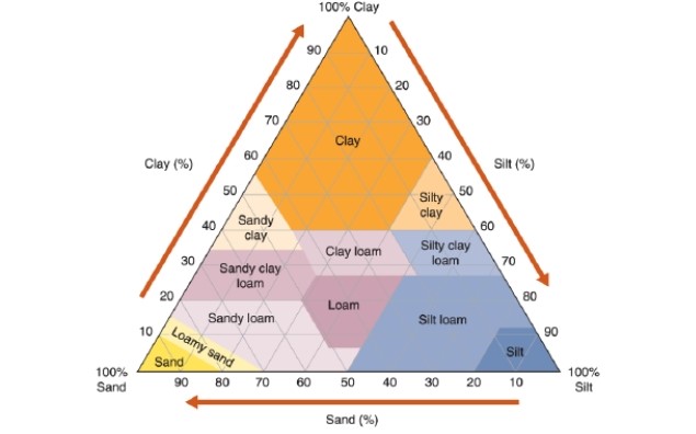
Reading this chart, what percentage of "silty clay" is composed of silt?
A)30 to 50%
B)40 to 60%
C)50 to 70%
D)60 to 80%
Question
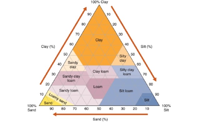
Reading this chart, what percentage of "silt loam" is composed of silt?
A)20 to 35%
B)30 to 45%
C)50 to 88%
D)60 to 100%
Question
Question
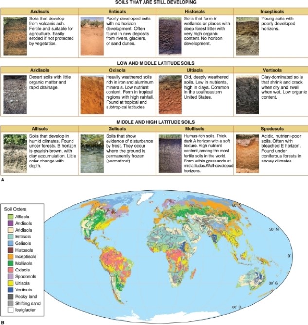
According to the figure, soils that form in coniferous forests with cold climates are called __________.
A)entisols
B)gelisols
C)oxisols
D)spodosols
Question
Question
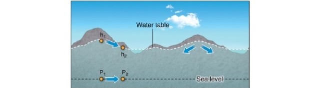
-In the figure, water flows from points P1 to P2 because __________.
A)there is less hydraulic pressure at P1 than P2
B)there is more hydraulic pressure at P1 than P2
C)there is an upward slope from P1 to P2
D)there is a downward slope from P1 to P2
Question
Question
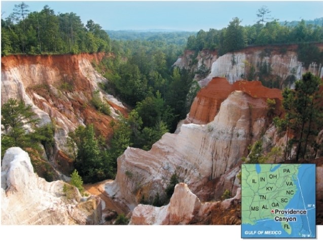
This photo shows Georgia's Providence Canyon.What human activity resulted in this canyon?
A)burning the forests
B)poor agricultural practices
C)overgrazing
D)These canyons are natural.
Question
Question
Question
Question
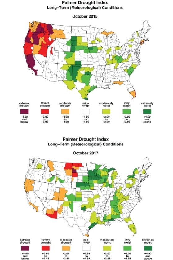
On the October 2017 map, which region shows the greatest moisture deficits?
A)the northern Great Plains, including Montana and the Dakotas
B)the western states of California, Oregon, and Washington
C)the southern states of Florida, Georgia, and the Carolinas
D)the northeastern states, including Maine, New Hampshire, and Vermont
Question

In the figure, dark brown soils indicate __________.
A)high organic content
B)strong weathering
C)persistent high water tables
D)heavy leaching of iron
Question
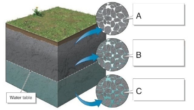
Which marked letter in this figure designates the capillary fringe?
A)A
B)B
C)C
D)All letters mark the capillary fringe
Question
Question
Question
Question
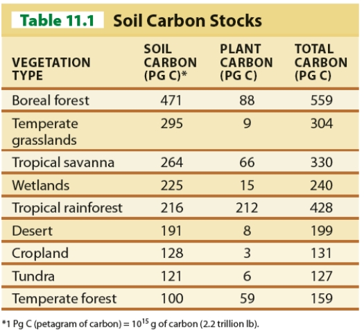
Using Table 11.1, which vegetation type has the highest soil-carbon content?
A)temperate grasslands
B)croplands
C)wetlands
D)boreal forest
Question
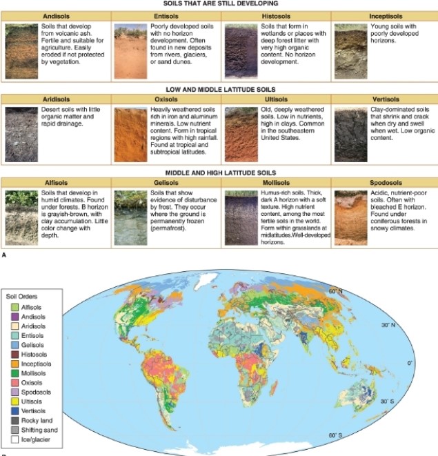
According to the figure, soils that occur where the ground is permanently frozen are called __________.
A)entisols
B)gelisols
C)oxisols
D)spodosols
Question
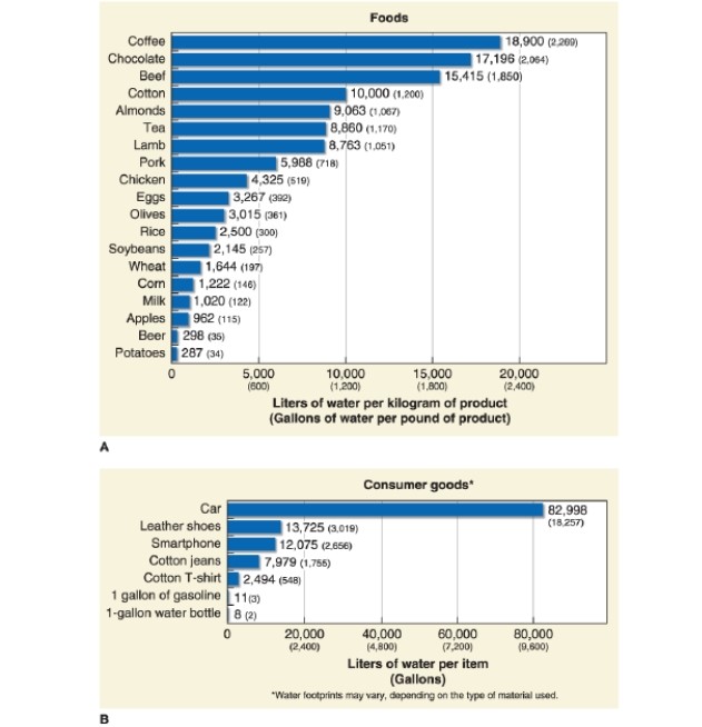
Referring to Figure 11.37, how many liters of water are required to make a single pair of cotton jeans?
A)3,569
B)4,032
C)7,979
D)9,562
Question
Question
Question
Question
Question
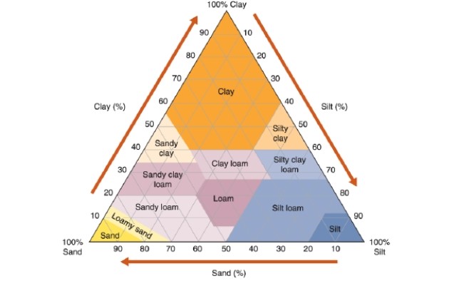
Reading this chart, what percentage of "sandy clay loam" is composed of clay?
A)20 to 35%
B)35 to 55%
C)50 to 70%
D)60 to 80%
Question
Question
Question
Question
Question

According to the figure, soils that commonly form in tropical regions with high rainfall are called __________.
A)mollisols
B)gelisols
C)oxisols
D)spodosols
Question
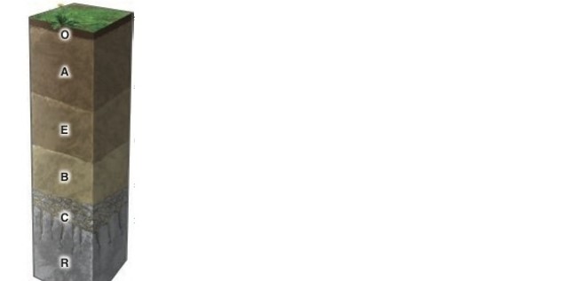
In the figure, which soil horizon is composed mainly of organic matter or humus?
A)O
B)A
C)E
D)B

Unlock Deck
Sign up to unlock the cards in this deck!
Unlock Deck
Unlock Deck
1/142
Play
Full screen (f)
Deck 11: Soil and Water Resources
1
Water withdrawals by people can lower the level of the water table.
True
2
The height of the water table usually changes by season.
True
3
Population growth and economic development often increase the demand for water resources.
True
4
Where natural springs arise, soils are wet.
Unlock Deck
Unlock for access to all 142 flashcards in this deck.
Unlock Deck
k this deck
5
Illuviation is the process whereby nutrients are restored to the upper layers of soil.
Unlock Deck
Unlock for access to all 142 flashcards in this deck.
Unlock Deck
k this deck
6
Fossil groundwater is water in an aquifer that is continually being replenished.
Unlock Deck
Unlock for access to all 142 flashcards in this deck.
Unlock Deck
k this deck
7
Groundwater mining occurs where water is taken from an aquifer that has rapid natural recharge.
Unlock Deck
Unlock for access to all 142 flashcards in this deck.
Unlock Deck
k this deck
8
Bedrock that is resistant to weathering forms soils more slowly than soft bedrock.
Unlock Deck
Unlock for access to all 142 flashcards in this deck.
Unlock Deck
k this deck
9
The Palmer Drought Severity Index is based on potential evapotranspiration rates.
Unlock Deck
Unlock for access to all 142 flashcards in this deck.
Unlock Deck
k this deck
10
Gentle slopes develop thicker soils than steep slopes.
Unlock Deck
Unlock for access to all 142 flashcards in this deck.
Unlock Deck
k this deck
11
Groundwater recharge occurs as water infiltrates the soil and enters the aquifer.
Unlock Deck
Unlock for access to all 142 flashcards in this deck.
Unlock Deck
k this deck
12
Groundwater supplies fluctuate relatively little compared to surface water supplies.
Unlock Deck
Unlock for access to all 142 flashcards in this deck.
Unlock Deck
k this deck
13
All groundwater extraction in Saudi Arabia is groundwater mining.
Unlock Deck
Unlock for access to all 142 flashcards in this deck.
Unlock Deck
k this deck
14
Soil color indicates what the soil is composed of and the climate under which it formed.
Unlock Deck
Unlock for access to all 142 flashcards in this deck.
Unlock Deck
k this deck
15
In the Northern Hemisphere, north-facing slopes are drier than south-facing slopes.
Unlock Deck
Unlock for access to all 142 flashcards in this deck.
Unlock Deck
k this deck
16
Aquifers form mostly in porous sediments and rocks.
Unlock Deck
Unlock for access to all 142 flashcards in this deck.
Unlock Deck
k this deck
17
Soil is the layer of sediment that has been modified by organisms and water, and is the region where plant roots extend.
Unlock Deck
Unlock for access to all 142 flashcards in this deck.
Unlock Deck
k this deck
18
Most aquifers are confined aquifers.
Unlock Deck
Unlock for access to all 142 flashcards in this deck.
Unlock Deck
k this deck
19
The best soils for agriculture have a loam texture.
Unlock Deck
Unlock for access to all 142 flashcards in this deck.
Unlock Deck
k this deck
20
Clay has greater permeability than sand.
Unlock Deck
Unlock for access to all 142 flashcards in this deck.
Unlock Deck
k this deck
21
Healthy topsoil does not have bacteria living in it.
Unlock Deck
Unlock for access to all 142 flashcards in this deck.
Unlock Deck
k this deck
22
A lack of water and soil resources was implicated in the downfall of the Maya.
Unlock Deck
Unlock for access to all 142 flashcards in this deck.
Unlock Deck
k this deck
23
Actual evapotranspiration is the amount of water that would evaporate and transpire from plants if it were available.
Unlock Deck
Unlock for access to all 142 flashcards in this deck.
Unlock Deck
k this deck
24
Potential evapotranspiration is the amount of water that evaporates and transpires from plants.
Unlock Deck
Unlock for access to all 142 flashcards in this deck.
Unlock Deck
k this deck
25
Soil erosion by wind removes particles of silt and clay before it removes sand.
Unlock Deck
Unlock for access to all 142 flashcards in this deck.
Unlock Deck
k this deck
26
Sand has high porosity and high permeability.
Unlock Deck
Unlock for access to all 142 flashcards in this deck.
Unlock Deck
k this deck
27
Water enters an aquifer through groundwater discharge.
Unlock Deck
Unlock for access to all 142 flashcards in this deck.
Unlock Deck
k this deck
28
The R horizon is the most important for growing food crops.
Unlock Deck
Unlock for access to all 142 flashcards in this deck.
Unlock Deck
k this deck
29
Clay has high porosity and low permeability.
Unlock Deck
Unlock for access to all 142 flashcards in this deck.
Unlock Deck
k this deck
30
Loam consists of about 70% sand, 20% silt, and 10% clay by volume.
Unlock Deck
Unlock for access to all 142 flashcards in this deck.
Unlock Deck
k this deck
31
Drought occurs when water deficits persist longer than normal for a region.
Unlock Deck
Unlock for access to all 142 flashcards in this deck.
Unlock Deck
k this deck
32
Groundwater in the southern Ogallala Aquifer is fossil groundwater.
Unlock Deck
Unlock for access to all 142 flashcards in this deck.
Unlock Deck
k this deck
33
Sandy soils and rocky soils have high organic content.
Unlock Deck
Unlock for access to all 142 flashcards in this deck.
Unlock Deck
k this deck
34
Groundwater overdraft can increase the height of the water table.
Unlock Deck
Unlock for access to all 142 flashcards in this deck.
Unlock Deck
k this deck
35
Soils contain components from all of Earth's major physical systems: the lithosphere, the biosphere, the atmosphere, and the hydrosphere.
Unlock Deck
Unlock for access to all 142 flashcards in this deck.
Unlock Deck
k this deck
36
All groundwater mining is unsustainable in the long term.
Unlock Deck
Unlock for access to all 142 flashcards in this deck.
Unlock Deck
k this deck
37
Soils develop slower in tropical climates than in cold climates and arid climates.
Unlock Deck
Unlock for access to all 142 flashcards in this deck.
Unlock Deck
k this deck
38
Soil erosion can change soil texture.
Unlock Deck
Unlock for access to all 142 flashcards in this deck.
Unlock Deck
k this deck
39
Worldwide, 844 million people (or about 1 in 9) do not have access to safe drinking water.
Unlock Deck
Unlock for access to all 142 flashcards in this deck.
Unlock Deck
k this deck
40
The horizontal layers in soils are called regoliths.
Unlock Deck
Unlock for access to all 142 flashcards in this deck.
Unlock Deck
k this deck
41
From the ground's surface downward, which sequence is in the correct order?
A)capillary fringe-zone of aeration-zone of saturation
B)zone of saturation-zone of aeration-capillary fringe
C)zone of aeration-capillary fringe-zone of saturation
D)zone of aeration-zone of saturation-capillary fringe
A)capillary fringe-zone of aeration-zone of saturation
B)zone of saturation-zone of aeration-capillary fringe
C)zone of aeration-capillary fringe-zone of saturation
D)zone of aeration-zone of saturation-capillary fringe
Unlock Deck
Unlock for access to all 142 flashcards in this deck.
Unlock Deck
k this deck
42
According to the map, most of the lowering of the water table level in the Ogallala Aquifer has occurred in the __________ portion(s) of the aquifer.
A)northwestern
B)northeastern
C)northeastern and central
D)central and southern
Unlock Deck
Unlock for access to all 142 flashcards in this deck.
Unlock Deck
k this deck
43
Which marked letter zone in this figure designates the zone of saturation?
A)A
B)B
C)C
D)All letters mark the zone of saturation
Unlock Deck
Unlock for access to all 142 flashcards in this deck.
Unlock Deck
k this deck
44
__________ is\are layers of soils that are identified by their different physical and chemical properties.
A)Regolith
B)Soil horizons
C)Soil orders
D)Soil texture
A)Regolith
B)Soil horizons
C)Soil orders
D)Soil texture
Unlock Deck
Unlock for access to all 142 flashcards in this deck.
Unlock Deck
k this deck
45
The layer of ground that is not permanently saturated is called the __________.
A)zone of aeration
B)zone of saturation
C)aquifer
D)water table
A)zone of aeration
B)zone of saturation
C)aquifer
D)water table
Unlock Deck
Unlock for access to all 142 flashcards in this deck.
Unlock Deck
k this deck
46
On the October 2015 map, which region shows the greatest moisture deficits?
A)the southeastern states
B)the western states
C)the Midwest
D)the East Coast
Unlock Deck
Unlock for access to all 142 flashcards in this deck.
Unlock Deck
k this deck
47
In the figure, red or orange soils indicate __________.
A)high organic content
B)strong weathering
C)persistent high water tables
D)heavy leaching of iron
Unlock Deck
Unlock for access to all 142 flashcards in this deck.
Unlock Deck
k this deck
48
Through the process of __________ rainwater carries soil particles downward and deeper into the soil.
A)eluviation
B)leaching
C)pedogenesis
D)illuviation
A)eluviation
B)leaching
C)pedogenesis
D)illuviation
Unlock Deck
Unlock for access to all 142 flashcards in this deck.
Unlock Deck
k this deck
49
Which climate zone has the deepest soils?
A)the polar high
B)the subpolar low
C)the subtropical high
D)the ITCZ
A)the polar high
B)the subpolar low
C)the subtropical high
D)the ITCZ
Unlock Deck
Unlock for access to all 142 flashcards in this deck.
Unlock Deck
k this deck
50
Reading this chart, what percentage of "silty clay" is composed of silt?
A)30 to 50%
B)40 to 60%
C)50 to 70%
D)60 to 80%
Unlock Deck
Unlock for access to all 142 flashcards in this deck.
Unlock Deck
k this deck
51
Reading this chart, what percentage of "silt loam" is composed of silt?
A)20 to 35%
B)30 to 45%
C)50 to 88%
D)60 to 100%
Unlock Deck
Unlock for access to all 142 flashcards in this deck.
Unlock Deck
k this deck
52
Rainwater moves particles and dissolved chemicals into the __________ soil horizon.
A)O
B)A
C)E
D)B
A)O
B)A
C)E
D)B
Unlock Deck
Unlock for access to all 142 flashcards in this deck.
Unlock Deck
k this deck
53
According to the figure, soils that form in coniferous forests with cold climates are called __________.
A)entisols
B)gelisols
C)oxisols
D)spodosols
Unlock Deck
Unlock for access to all 142 flashcards in this deck.
Unlock Deck
k this deck
54
Particle sizes of 0.002 to 0.05 millimeters are classified as __________.
A)sand
B)silt
C)clay
D)gravel
A)sand
B)silt
C)clay
D)gravel
Unlock Deck
Unlock for access to all 142 flashcards in this deck.
Unlock Deck
k this deck
55
-In the figure, water flows from points P1 to P2 because __________.
A)there is less hydraulic pressure at P1 than P2
B)there is more hydraulic pressure at P1 than P2
C)there is an upward slope from P1 to P2
D)there is a downward slope from P1 to P2
Unlock Deck
Unlock for access to all 142 flashcards in this deck.
Unlock Deck
k this deck
56
Drought does what to groundwater?
A)It raises the height of the water table.
B)It lowers the height of the water table.
C)It increases the permeability of the soil.
D)It has little effect on groundwater
A)It raises the height of the water table.
B)It lowers the height of the water table.
C)It increases the permeability of the soil.
D)It has little effect on groundwater
Unlock Deck
Unlock for access to all 142 flashcards in this deck.
Unlock Deck
k this deck
57
This photo shows Georgia's Providence Canyon.What human activity resulted in this canyon?
A)burning the forests
B)poor agricultural practices
C)overgrazing
D)These canyons are natural.
Unlock Deck
Unlock for access to all 142 flashcards in this deck.
Unlock Deck
k this deck
58
Why does groundwater become more expensive as the water table lowers?
A)because there is more competition for it, driving up prices
B)because it takes more energy and expense to pump it from greater depths
C)because the water must be cleaned and processed
D)The cost of groundwater does not increase as the water table lowers
A)because there is more competition for it, driving up prices
B)because it takes more energy and expense to pump it from greater depths
C)because the water must be cleaned and processed
D)The cost of groundwater does not increase as the water table lowers
Unlock Deck
Unlock for access to all 142 flashcards in this deck.
Unlock Deck
k this deck
59
__________ occurs in wells in coastal areas when water is taken from an aquifer faster than it is replenished through recharge.
A)Groundwater overdraft
B)Saltwater intrusion
C)A perched aquifer
D)Land subsidence
A)Groundwater overdraft
B)Saltwater intrusion
C)A perched aquifer
D)Land subsidence
Unlock Deck
Unlock for access to all 142 flashcards in this deck.
Unlock Deck
k this deck
60
Most lakes and streams reveal what about groundwater?
A)the height of the water table
B)the permeability of the ground
C)the direction of groundwater movement
D)the size of the aquifer
A)the height of the water table
B)the permeability of the ground
C)the direction of groundwater movement
D)the size of the aquifer
Unlock Deck
Unlock for access to all 142 flashcards in this deck.
Unlock Deck
k this deck
61
On the October 2017 map, which region shows the greatest moisture deficits?
A)the northern Great Plains, including Montana and the Dakotas
B)the western states of California, Oregon, and Washington
C)the southern states of Florida, Georgia, and the Carolinas
D)the northeastern states, including Maine, New Hampshire, and Vermont
Unlock Deck
Unlock for access to all 142 flashcards in this deck.
Unlock Deck
k this deck
62
In the figure, dark brown soils indicate __________.
A)high organic content
B)strong weathering
C)persistent high water tables
D)heavy leaching of iron
Unlock Deck
Unlock for access to all 142 flashcards in this deck.
Unlock Deck
k this deck
63
Which marked letter in this figure designates the capillary fringe?
A)A
B)B
C)C
D)All letters mark the capillary fringe
Unlock Deck
Unlock for access to all 142 flashcards in this deck.
Unlock Deck
k this deck
64
Through the process of __________ rainwater carries dissolved nutrients downward and deeper into the soil.
A)eluviation
B)leaching
C)pedogenesis
D)illuviation
A)eluviation
B)leaching
C)pedogenesis
D)illuviation
Unlock Deck
Unlock for access to all 142 flashcards in this deck.
Unlock Deck
k this deck
65
The most important soil-loss factor is due to __________.
A)road building
B)human settlement
C)erosion
D)poisoning
A)road building
B)human settlement
C)erosion
D)poisoning
Unlock Deck
Unlock for access to all 142 flashcards in this deck.
Unlock Deck
k this deck
66
Which is not considered when evaluating soil's texture?
A)sand content
B)water content
C)silt content
D)clay content
A)sand content
B)water content
C)silt content
D)clay content
Unlock Deck
Unlock for access to all 142 flashcards in this deck.
Unlock Deck
k this deck
67
Using Table 11.1, which vegetation type has the highest soil-carbon content?
A)temperate grasslands
B)croplands
C)wetlands
D)boreal forest
Unlock Deck
Unlock for access to all 142 flashcards in this deck.
Unlock Deck
k this deck
68
According to the figure, soils that occur where the ground is permanently frozen are called __________.
A)entisols
B)gelisols
C)oxisols
D)spodosols
Unlock Deck
Unlock for access to all 142 flashcards in this deck.
Unlock Deck
k this deck
69
Referring to Figure 11.37, how many liters of water are required to make a single pair of cotton jeans?
A)3,569
B)4,032
C)7,979
D)9,562
Unlock Deck
Unlock for access to all 142 flashcards in this deck.
Unlock Deck
k this deck
70
Plaggen soils occur where?
A)in the Amazon rainforest
B)in equatorial Africa
C)in the eastern deciduous forest
D)in Europe
A)in the Amazon rainforest
B)in equatorial Africa
C)in the eastern deciduous forest
D)in Europe
Unlock Deck
Unlock for access to all 142 flashcards in this deck.
Unlock Deck
k this deck
71
The average topsoil depth worldwide ranges from __________ centimeters.
A)1 to 5
B)5 to 20
C)20 to 30
D)30 to 65
A)1 to 5
B)5 to 20
C)20 to 30
D)30 to 65
Unlock Deck
Unlock for access to all 142 flashcards in this deck.
Unlock Deck
k this deck
72
__________ is the practice of creating shelves of standing water on very steep slopes to grow crops, notably rice.
A)Composting
B)Terracing
C)Contour plowing
D)Leaching
A)Composting
B)Terracing
C)Contour plowing
D)Leaching
Unlock Deck
Unlock for access to all 142 flashcards in this deck.
Unlock Deck
k this deck
73
The __________ soil horizon is also called topsoil.
A)A
B)C
C)E
D)B
A)A
B)C
C)E
D)B
Unlock Deck
Unlock for access to all 142 flashcards in this deck.
Unlock Deck
k this deck
74
Reading this chart, what percentage of "sandy clay loam" is composed of clay?
A)20 to 35%
B)35 to 55%
C)50 to 70%
D)60 to 80%
Unlock Deck
Unlock for access to all 142 flashcards in this deck.
Unlock Deck
k this deck
75
The actions of living organisms are concentrated in the __________ soil horizon.
A)A
B)E
C)B
D)C
A)A
B)E
C)B
D)C
Unlock Deck
Unlock for access to all 142 flashcards in this deck.
Unlock Deck
k this deck
76
Which of the following materials is most permeable?
A)silt
B)clay
C)sand
D)gravel
A)silt
B)clay
C)sand
D)gravel
Unlock Deck
Unlock for access to all 142 flashcards in this deck.
Unlock Deck
k this deck
77
A(n) __________ is any sediment or rock with pore spaces that contain water.
A)aquiclude
B)aquifer
C)spring
D)capillary fringe
A)aquiclude
B)aquifer
C)spring
D)capillary fringe
Unlock Deck
Unlock for access to all 142 flashcards in this deck.
Unlock Deck
k this deck
78
Which factor is not considered by the Thornthwaite system that determines water availability in a given region?
A)the amount of precipitation
B)actual evapotranspiration rates
C)potential evapotranspiration rates
D)atmospheric humidity
A)the amount of precipitation
B)actual evapotranspiration rates
C)potential evapotranspiration rates
D)atmospheric humidity
Unlock Deck
Unlock for access to all 142 flashcards in this deck.
Unlock Deck
k this deck
79
According to the figure, soils that commonly form in tropical regions with high rainfall are called __________.
A)mollisols
B)gelisols
C)oxisols
D)spodosols
Unlock Deck
Unlock for access to all 142 flashcards in this deck.
Unlock Deck
k this deck
80
In the figure, which soil horizon is composed mainly of organic matter or humus?
A)O
B)A
C)E
D)B
Unlock Deck
Unlock for access to all 142 flashcards in this deck.
Unlock Deck
k this deck
Unlock Deck
Unlock for access to all 142 flashcards in this deck.


