Deck 1: Introduction
ملء الشاشة (f)
سؤال
سؤال
According to the figure below,which location has the least amount of volcanic activity? 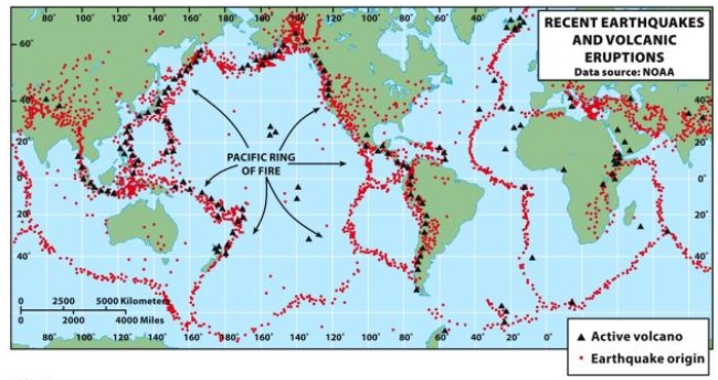
A) the United States
B) South America
C) Subsaharan Africa
D) East Asia
E) Australia
A) the United States
B) South America
C) Subsaharan Africa
D) East Asia
E) Australia
سؤال
سؤال
سؤال
سؤال
سؤال
سؤال
سؤال
سؤال
سؤال
سؤال
سؤال
سؤال
سؤال
In Figure G-2,which of the maps has the largest scale? 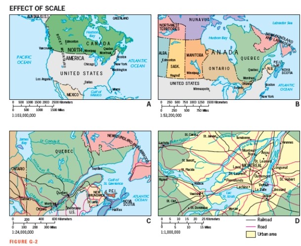
A) Map A
B) Map B
C) Map C
D) Map D
E) They all have the same scale.
A) Map A
B) Map B
C) Map C
D) Map D
E) They all have the same scale.
سؤال
سؤال
سؤال
سؤال
سؤال
سؤال
سؤال
سؤال
Figure G-10 shows that is the most dominant religion in the northern part of Africa: 
A) Shia Islam
B) Sunni Islam
C) Traditional and Shamanist faiths
D) Roman Catholicism
E) Hinduism
A) Shia Islam
B) Sunni Islam
C) Traditional and Shamanist faiths
D) Roman Catholicism
E) Hinduism
سؤال
سؤال
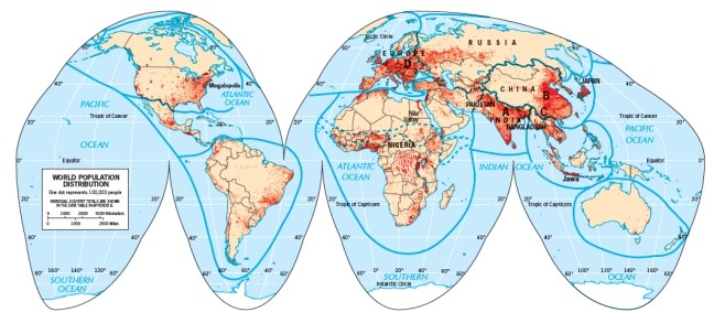
Which of the following realms contains one of the top three population clusters but lies entirely outside of the Global Core according to Figure G-12: 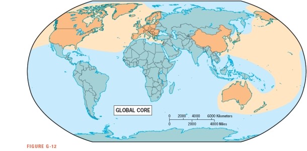
A) Europe
B) North America
C) East Asia
D) South Asia
E) Austral Realm
A) Europe
B) North America
C) East Asia
D) South Asia
E) Austral Realm
سؤال
سؤال
Which of these countries is NOT considered a high-income economy,as classified by the World Bank in Figure G-11? 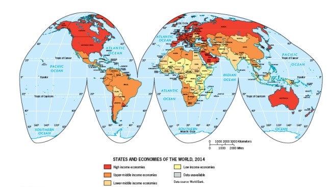
A) the United States
B) Canada
C) China
D) Japan
E) Australia
A) the United States
B) Canada
C) China
D) Japan
E) Australia
سؤال
According to Figure G-5,which U.S.city was NOT covered by glaciers during the Pleistocene? 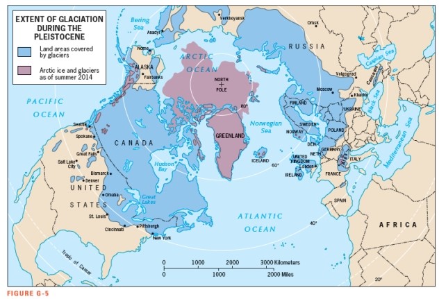
A) Seattle
B) Omaha
C) Cincinnati
D) Denver
E) New York City
A) Seattle
B) Omaha
C) Cincinnati
D) Denver
E) New York City
سؤال
سؤال
سؤال
سؤال
سؤال
سؤال
سؤال
سؤال
سؤال
سؤال
Figure G-8 shows that the English language belongs to the language family. 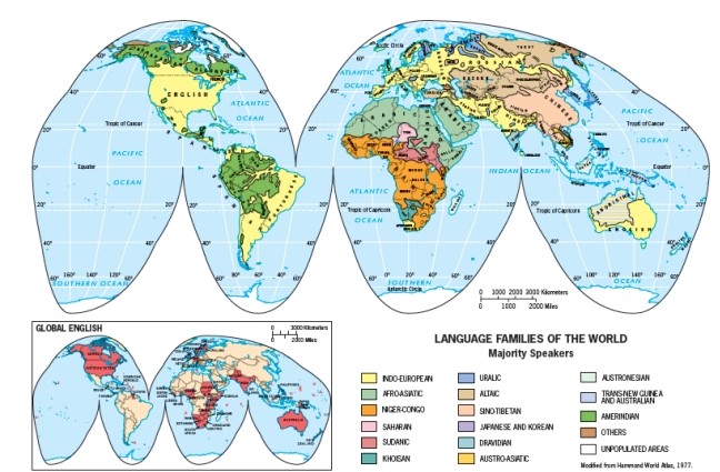
A) Indo-European
B) Altaic
C) Dravidian
D) Amerindian
E) Uralic
A) Indo-European
B) Altaic
C) Dravidian
D) Amerindian
E) Uralic
سؤال
سؤال
سؤال
سؤال
سؤال
سؤال
سؤال
سؤال
سؤال
سؤال
سؤال
سؤال
سؤال
سؤال
سؤال
سؤال
سؤال
سؤال
سؤال
سؤال
سؤال
سؤال
سؤال
سؤال
سؤال
سؤال
سؤال
سؤال
سؤال
سؤال
From Figure G-7 it appears that the eastern half of China is more densely populated than the western half.
سؤال
سؤال
سؤال
سؤال
سؤال
سؤال
سؤال
سؤال
سؤال
سؤال
سؤال
سؤال

فتح الحزمة
قم بالتسجيل لفتح البطاقات في هذه المجموعة!
Unlock Deck
Unlock Deck
1/87
العب
ملء الشاشة (f)
Deck 1: Introduction
1
The prevailing mid-latitude climatic type in the southeastern United States,Western Europe,southern Brazil,northern Argentina,and eastern China,is the _______________.
A) humid cold
B) semiarid moderate
C) humid temperate
D) dry winter tundra
E) dry summer savanna
A) humid cold
B) semiarid moderate
C) humid temperate
D) dry winter tundra
E) dry summer savanna
C
2
According to the figure below,which location has the least amount of volcanic activity?
A) the United States
B) South America
C) Subsaharan Africa
D) East Asia
E) Australia
A) the United States
B) South America
C) Subsaharan Africa
D) East Asia
E) Australia
E
3
Wegener's supercontinent is known as ____________.
A) Tectonica
B) Atlantis
C) Eurasia
D) Pangaea
E) Wegneria
A) Tectonica
B) Atlantis
C) Eurasia
D) Pangaea
E) Wegneria
D
4
All regions possess all of the following EXCEPT ____________.
A) absolute location
B) area
C) homogeneity
D) boundaries
E) relative location
A) absolute location
B) area
C) homogeneity
D) boundaries
E) relative location
فتح الحزمة
افتح القفل للوصول البطاقات البالغ عددها 87 في هذه المجموعة.
فتح الحزمة
k this deck
5
Which of the following statements concerning map scale is false?
A) The fractional scale 1:1,000,000 means one inch on the map represents one million inches on the ground.
B) If the linear scale of a map is twice another, its areal representation is four times larger.
C) To represent a large area on a small map, a small scale is used.
D) Larger-scale maps allow for greater detail in depicting regions and subregions.
E) A map with the fractional scale 1:103,000,000 has a larger scale than one of 1:1,000,000.
فتح الحزمة
افتح القفل للوصول البطاقات البالغ عددها 87 في هذه المجموعة.
فتح الحزمة
k this deck
6
A large-scale map shows _______________.
A) a small area
B) a large area
C) no relationship between the scale on a map and the size of the area shown
D) an unbalanced area
E) the entire world
A) a small area
B) a large area
C) no relationship between the scale on a map and the size of the area shown
D) an unbalanced area
E) the entire world
فتح الحزمة
افتح القفل للوصول البطاقات البالغ عددها 87 في هذه المجموعة.
فتح الحزمة
k this deck
7
The ratio of distance on a map to actual ground distance is known as the ____________.
A) map legend
B) map scale
C) map revolution
D) cartographic rule
E) purpose of the map
A) map legend
B) map scale
C) map revolution
D) cartographic rule
E) purpose of the map
فتح الحزمة
افتح القفل للوصول البطاقات البالغ عددها 87 في هذه المجموعة.
فتح الحزمة
k this deck
8
Which of the following statements about the A climates is INCORRECT?
A) They are referred to as humid equatorial climates.
B) They are characterized by heavy precipitation and high year-round temperatures.
C) In the Af climate, precipitation rates increase suddenly due to the arrival of the wet monsoon.
D) The Aw subtype is identified as savanna.
E) They include monsoon climates.
فتح الحزمة
افتح القفل للوصول البطاقات البالغ عددها 87 في هذه المجموعة.
فتح الحزمة
k this deck
9
The area that surrounds and is served by a city is known as its _____________.
A) periphery
B) formal region
C) hinterland
D) core
E) relative location
A) periphery
B) formal region
C) hinterland
D) core
E) relative location
فتح الحزمة
افتح القفل للوصول البطاقات البالغ عددها 87 في هذه المجموعة.
فتح الحزمة
k this deck
10
Which of the following statements is INCORRECT?
A) Regions marked by internal homogeneity are classified as formal regions.
B) Regions conceptualized as "spatial systems" are collectively identified as functional regions.
C) A country likely constitutes a formal political region because within its boundaries certain conditions of nationality, law, and political tradition prevail.
D) Functional regions are generally more static and internally immobile than formal regions.
E) Functional regions have a core and a periphery.
فتح الحزمة
افتح القفل للوصول البطاقات البالغ عددها 87 في هذه المجموعة.
فتح الحزمة
k this deck
11
Savanna environments belong to the general climate type known as _____________.
A) dry
B) humid cold
C) humid temperate
D) humid equatorial
E) polar
A) dry
B) humid cold
C) humid temperate
D) humid equatorial
E) polar
فتح الحزمة
افتح القفل للوصول البطاقات البالغ عددها 87 في هذه المجموعة.
فتح الحزمة
k this deck
12
The hypothesis of ________ involves the breakup of a supercontinent that existed hundreds of millions of years ago.
A) volcanic eruption
B) earthquake formation
C) continental drift
D) tectonic ring firing
E) natural hazardification
A) volcanic eruption
B) earthquake formation
C) continental drift
D) tectonic ring firing
E) natural hazardification
فتح الحزمة
افتح القفل للوصول البطاقات البالغ عددها 87 في هذه المجموعة.
فتح الحزمة
k this deck
13
A functional region _______________.
A) is defined on the basis of some variable, such as the area where wheat is grown
B) is exemplified by a city and its hinterland
C) is also known as a formal region
D) has a transition zone at its center
E) is the same as a uniform region
A) is defined on the basis of some variable, such as the area where wheat is grown
B) is exemplified by a city and its hinterland
C) is also known as a formal region
D) has a transition zone at its center
E) is the same as a uniform region
فتح الحزمة
افتح القفل للوصول البطاقات البالغ عددها 87 في هذه المجموعة.
فتح الحزمة
k this deck
14
Which of the following is the process whereby the sun's radiation is trapped in the Earth's atmosphere.
A) desertification
B) continental drift
C) interglaciation
D) greenhouse effect
E) There is no such effect.
A) desertification
B) continental drift
C) interglaciation
D) greenhouse effect
E) There is no such effect.
فتح الحزمة
افتح القفل للوصول البطاقات البالغ عددها 87 في هذه المجموعة.
فتح الحزمة
k this deck
15
In Figure G-2,which of the maps has the largest scale?
A) Map A
B) Map B
C) Map C
D) Map D
E) They all have the same scale.
A) Map A
B) Map B
C) Map C
D) Map D
E) They all have the same scale.
فتح الحزمة
افتح القفل للوصول البطاقات البالغ عددها 87 في هذه المجموعة.
فتح الحزمة
k this deck
16
In regional geography,relative location _______________.
A) is more meaningful and practical than absolute location
B) refers to the latitude of a place
C) refers to the longitudinal position of a place
D) can only be found using a GIS
E) is a type of transition zone
A) is more meaningful and practical than absolute location
B) refers to the latitude of a place
C) refers to the longitudinal position of a place
D) can only be found using a GIS
E) is a type of transition zone
فتح الحزمة
افتح القفل للوصول البطاقات البالغ عددها 87 في هذه المجموعة.
فتح الحزمة
k this deck
17
Which water body is surrounded by the geologically active Ring of Fire?
A) the North American Great Lakes
B) the Arctic Ocean
C) the Atlantic Ocean
D) the Pacific Ocean
E) the Gulf of Mexico
A) the North American Great Lakes
B) the Arctic Ocean
C) the Atlantic Ocean
D) the Pacific Ocean
E) the Gulf of Mexico
فتح الحزمة
افتح القفل للوصول البطاقات البالغ عددها 87 في هذه المجموعة.
فتح الحزمة
k this deck
18
The difference between formal and functional regions is _____________________.
A) the nature of the unifying properties: static homogeneity versus functional cohesion
B) the area involved: Formal areas are very large, while functional areas are smaller
C) the formal region is urban in nature, whereas the functional region is rural
D) the age of the regions: The functional region is normally much older than the formal region
E) the formal region characterizes the non-Western world, whereas the functional region is typically European or North American
فتح الحزمة
افتح القفل للوصول البطاقات البالغ عددها 87 في هذه المجموعة.
فتح الحزمة
k this deck
19
Which of the following statements is TRUE?
A) Desertification occurs only on the Eurasian landmass.
B) The climate type of the southwestern United States is similar to that of southwestern Africa.
C) The term climate refers to the immediate state of the atmosphere.
D) Alfred Wegener derived the theory of climatic regions.
E) We are currently in the post-Holocene geologic epoch.
فتح الحزمة
افتح القفل للوصول البطاقات البالغ عددها 87 في هذه المجموعة.
فتح الحزمة
k this deck
20
The current interglacial period is known as the _____________.
A) Wisconsinan
B) Wegnerian
C) Pleistocene
D) Little Ice Age
E) Holocene
A) Wisconsinan
B) Wegnerian
C) Pleistocene
D) Little Ice Age
E) Holocene
فتح الحزمة
افتح القفل للوصول البطاقات البالغ عددها 87 في هذه المجموعة.
فتح الحزمة
k this deck
21
The World Bank ranks countries within four groups.Which of the following is NOT one of those groups?
A) high-income countries
B) upper-middle-income countries
C) lower-middle-income countries
D) middle-income countries
E) low-income countries
A) high-income countries
B) upper-middle-income countries
C) lower-middle-income countries
D) middle-income countries
E) low-income countries
فتح الحزمة
افتح القفل للوصول البطاقات البالغ عددها 87 في هذه المجموعة.
فتح الحزمة
k this deck
22
Desertification in Subsaharan Africa would MOST likely be enhanced by winds blowing from the:
A) East
B) Southeast
C)South
D) Northeast
E) Southwest
A) East
B) Southeast
C)South
D) Northeast
E) Southwest
فتح الحزمة
افتح القفل للوصول البطاقات البالغ عددها 87 في هذه المجموعة.
فتح الحزمة
k this deck
23
Figure G-10 shows that is the most dominant religion in the northern part of Africa:
A) Shia Islam
B) Sunni Islam
C) Traditional and Shamanist faiths
D) Roman Catholicism
E) Hinduism
A) Shia Islam
B) Sunni Islam
C) Traditional and Shamanist faiths
D) Roman Catholicism
E) Hinduism
فتح الحزمة
افتح القفل للوصول البطاقات البالغ عددها 87 في هذه المجموعة.
فتح الحزمة
k this deck
24
Effects of glaciation would be LEAST prevalent upon
A) The shape of landmasses
B) Inland bodies of water
C) The growth of cities
D) Sea levels
E) Human migration
A) The shape of landmasses
B) Inland bodies of water
C) The growth of cities
D) Sea levels
E) Human migration
فتح الحزمة
افتح القفل للوصول البطاقات البالغ عددها 87 في هذه المجموعة.
فتح الحزمة
k this deck
25
Which of the following realms contains one of the top three population clusters but lies entirely outside of the Global Core according to Figure G-12:
A) Europe
B) North America
C) East Asia
D) South Asia
E) Austral Realm
A) Europe
B) North America
C) East Asia
D) South Asia
E) Austral Realm
فتح الحزمة
افتح القفل للوصول البطاقات البالغ عددها 87 في هذه المجموعة.
فتح الحزمة
k this deck
26
Friction between which two tectonic plates is likely to have caused the earthquake in Nepal in Spring,2015?
A) African and Arabian
B) Indian and Eurasian
C) South American and Nazca
D)Pacific and Australian
E) North American and Pacific
A) African and Arabian
B) Indian and Eurasian
C) South American and Nazca
D)Pacific and Australian
E) North American and Pacific
فتح الحزمة
افتح القفل للوصول البطاقات البالغ عددها 87 في هذه المجموعة.
فتح الحزمة
k this deck
27
Which of these countries is NOT considered a high-income economy,as classified by the World Bank in Figure G-11?
A) the United States
B) Canada
C) China
D) Japan
E) Australia
A) the United States
B) Canada
C) China
D) Japan
E) Australia
فتح الحزمة
افتح القفل للوصول البطاقات البالغ عددها 87 في هذه المجموعة.
فتح الحزمة
k this deck
28
According to Figure G-5,which U.S.city was NOT covered by glaciers during the Pleistocene?
A) Seattle
B) Omaha
C) Cincinnati
D) Denver
E) New York City
A) Seattle
B) Omaha
C) Cincinnati
D) Denver
E) New York City
فتح الحزمة
افتح القفل للوصول البطاقات البالغ عددها 87 في هذه المجموعة.
فتح الحزمة
k this deck
29
Which of the following statements about the Global Core is INCORRECT?
A) It was formed before the 20ᵗʰ century
B) It is a good example of a functional region
C) It now contains Canada, Germany, Japan, and China
D) It is a component of an international spatial-economic system
E) It is subservient to the Global Periphery
A) It was formed before the 20ᵗʰ century
B) It is a good example of a functional region
C) It now contains Canada, Germany, Japan, and China
D) It is a component of an international spatial-economic system
E) It is subservient to the Global Periphery
فتح الحزمة
افتح القفل للوصول البطاقات البالغ عددها 87 في هذه المجموعة.
فتح الحزمة
k this deck
30
Which of the following is NOT an example of globalization?
A) McDonald's expansion into China
B) FIFA (International Federation of Association Football)
C) the worldwide dominance of English
D) Japanese cars assembled in Thailand
E) tariffs imposed on foreign automobiles
A) McDonald's expansion into China
B) FIFA (International Federation of Association Football)
C) the worldwide dominance of English
D) Japanese cars assembled in Thailand
E) tariffs imposed on foreign automobiles
فتح الحزمة
افتح القفل للوصول البطاقات البالغ عددها 87 في هذه المجموعة.
فتح الحزمة
k this deck
31
Which of the following is a systematic subfield of geography?
A) regional geography
B) cartography
C) Geographic Information Science (GIS)
D) cultural geography
E) geology
A) regional geography
B) cartography
C) Geographic Information Science (GIS)
D) cultural geography
E) geology
فتح الحزمة
افتح القفل للوصول البطاقات البالغ عددها 87 في هذه المجموعة.
فتح الحزمة
k this deck
32
An index of regional disparity would be useful for examining _________________.
A) economic differences between different regions of a country
B) political differences between functional and formal regions
C) climatic differences between core and periphery
D) similarities among African and Asian countries
E) differences between the Western and Eastern Hemispheres
A) economic differences between different regions of a country
B) political differences between functional and formal regions
C) climatic differences between core and periphery
D) similarities among African and Asian countries
E) differences between the Western and Eastern Hemispheres
فتح الحزمة
افتح القفل للوصول البطاقات البالغ عددها 87 في هذه المجموعة.
فتح الحزمة
k this deck
33
Which of the following statements is INCORRECT?
A) China now has more people living in cities than in rural areas.
B) East Asia's population is projected to remain larger than South Asia's for the rest of this century.
C) The eastern North American population cluster is only about one-fourth the size of Europe's.
D) The world's three largest population clusters are all located on the Eurasian landmass.
E) Europe's population is predominantly urban.
فتح الحزمة
افتح القفل للوصول البطاقات البالغ عددها 87 في هذه المجموعة.
فتح الحزمة
k this deck
34
States first began to develop _____________________.
A) in areas where cities could begin to command their hinterlands
B) in open areas between empires
C) in nineteenth-century Europe
D) in areas where boundaries had already been drawn by royal decree
E) They have always existed.
A) in areas where cities could begin to command their hinterlands
B) in open areas between empires
C) in nineteenth-century Europe
D) in areas where boundaries had already been drawn by royal decree
E) They have always existed.
فتح الحزمة
افتح القفل للوصول البطاقات البالغ عددها 87 في هذه المجموعة.
فتح الحزمة
k this deck
35
Which country is NOT located within one of the world's three largest population clusters:
A) South Korea
B) the United States
C) Pakistan
D) France
E) China
A) South Korea
B) the United States
C) Pakistan
D) France
E) China
فتح الحزمة
افتح القفل للوصول البطاقات البالغ عددها 87 في هذه المجموعة.
فتح الحزمة
k this deck
36
The European state model includes all of the following except ______________.
A) a population governed from a capital city
B) a clearly and legally defined territory
C) a representative government
D) a high level of urbanization
E) a concept developed during the seventeenth century in Europe.
A) a population governed from a capital city
B) a clearly and legally defined territory
C) a representative government
D) a high level of urbanization
E) a concept developed during the seventeenth century in Europe.
فتح الحزمة
افتح القفل للوصول البطاقات البالغ عددها 87 في هذه المجموعة.
فتح الحزمة
k this deck
37
The large cluster of population in South Asia is focused on the ______ River Basin.
A) Yellow
B) Amazon
C) Nile
D) Ganges
E) Yangzi
A) Yellow
B) Amazon
C) Nile
D) Ganges
E) Yangzi
فتح الحزمة
افتح القفل للوصول البطاقات البالغ عددها 87 في هذه المجموعة.
فتح الحزمة
k this deck
38
Figure G-8 shows that the English language belongs to the language family.
A) Indo-European
B) Altaic
C) Dravidian
D) Amerindian
E) Uralic
A) Indo-European
B) Altaic
C) Dravidian
D) Amerindian
E) Uralic
فتح الحزمة
افتح القفل للوصول البطاقات البالغ عددها 87 في هذه المجموعة.
فتح الحزمة
k this deck
39
The gradual reduction of regional contrasts resulting from increasing cultural,economic,political and other types of exchanges is known as ______________.
A) regional disparity
B) regional equalization
C) world flattening
D) the European trade model
E) globalization
A) regional disparity
B) regional equalization
C) world flattening
D) the European trade model
E) globalization
فتح الحزمة
افتح القفل للوصول البطاقات البالغ عددها 87 في هذه المجموعة.
فتح الحزمة
k this deck
40
Which of the following major rivers is NOT associated with one of the world's great population clusters?
A) Mississippi
B) Huang (Yellow)
C) Rhine
D) Ganges
E) Chang Jiang (Yangzi)
A) Mississippi
B) Huang (Yellow)
C) Rhine
D) Ganges
E) Chang Jiang (Yangzi)
فتح الحزمة
افتح القفل للوصول البطاقات البالغ عددها 87 في هذه المجموعة.
فتح الحزمة
k this deck
41
In land area,Russia is the largest nation on earth.
فتح الحزمة
افتح القفل للوصول البطاقات البالغ عددها 87 في هذه المجموعة.
فتح الحزمة
k this deck
42
In the Köppen-Geiger scheme,the world's drier climates are largely grouped under the letter A.
فتح الحزمة
افتح القفل للوصول البطاقات البالغ عددها 87 في هذه المجموعة.
فتح الحزمة
k this deck
43
The D climates are humid cold climates.
فتح الحزمة
افتح القفل للوصول البطاقات البالغ عددها 87 في هذه المجموعة.
فتح الحزمة
k this deck
44
Map scale is the ratio of the distance between two places on a map and the actual distance between those two places on the Earth's surface.
فتح الحزمة
افتح القفل للوصول البطاقات البالغ عددها 87 في هذه المجموعة.
فتح الحزمة
k this deck
45
The Holocene is the name of the most recent glaciation.
فتح الحزمة
افتح القفل للوصول البطاقات البالغ عددها 87 في هذه المجموعة.
فتح الحزمة
k this deck
46
Pangaea is the name of Wegener's supercontinent.
فتح الحزمة
افتح القفل للوصول البطاقات البالغ عددها 87 في هذه المجموعة.
فتح الحزمة
k this deck
47
A world map is a small-scale map.
فتح الحزمة
افتح القفل للوصول البطاقات البالغ عددها 87 في هذه المجموعة.
فتح الحزمة
k this deck
48
Geography is concerned with providing a spatial perspective on the world.
فتح الحزمة
افتح القفل للوصول البطاقات البالغ عددها 87 في هذه المجموعة.
فتح الحزمة
k this deck
49
Weather is a momentary phenomenon,whereas climate refers to atmospheric conditions over the entire period for which records are available.
فتح الحزمة
افتح القفل للوصول البطاقات البالغ عددها 87 في هذه المجموعة.
فتح الحزمة
k this deck
50
Relative location has far less relevance in human geography than absolute location.
فتح الحزمة
افتح القفل للوصول البطاقات البالغ عددها 87 في هذه المجموعة.
فتح الحزمة
k this deck
51
A region organized around a central urban core is known as a functional region.
فتح الحزمة
افتح القفل للوصول البطاقات البالغ عددها 87 في هذه المجموعة.
فتح الحزمة
k this deck
52
Besides location,a region must also possess areal extent.
فتح الحزمة
افتح القفل للوصول البطاقات البالغ عددها 87 في هذه المجموعة.
فتح الحزمة
k this deck
53
Population density refers to the number of persons per unit area.
فتح الحزمة
افتح القفل للوصول البطاقات البالغ عددها 87 في هذه المجموعة.
فتح الحزمة
k this deck
54
Wladimir Köppen developed the hypothesis of continental drift.
فتح الحزمة
افتح القفل للوصول البطاقات البالغ عددها 87 في هذه المجموعة.
فتح الحزمة
k this deck
55
A region need not possess the geographic property of relative location.
فتح الحزمة
افتح القفل للوصول البطاقات البالغ عددها 87 في هذه المجموعة.
فتح الحزمة
k this deck
56
Transition zones often mark the places where geographic realms meet.
فتح الحزمة
افتح القفل للوصول البطاقات البالغ عددها 87 في هذه المجموعة.
فتح الحزمة
k this deck
57
A region marked by homogeneity is known as a functional region.
فتح الحزمة
افتح القفل للوصول البطاقات البالغ عددها 87 في هذه المجموعة.
فتح الحزمة
k this deck
58
A mental map shows an area committed to a person's memory.
فتح الحزمة
افتح القفل للوصول البطاقات البالغ عددها 87 في هذه المجموعة.
فتح الحزمة
k this deck
59
Cartography is the new science of making maps with computers.
فتح الحزمة
افتح القفل للوصول البطاقات البالغ عددها 87 في هذه المجموعة.
فتح الحزمة
k this deck
60
To find a city street,a small-scale map should be used.
فتح الحزمة
افتح القفل للوصول البطاقات البالغ عددها 87 في هذه المجموعة.
فتح الحزمة
k this deck
61
The ratio of distance on a map to actual ground distance is known as that map's ___.
فتح الحزمة
افتح القفل للوصول البطاقات البالغ عددها 87 في هذه المجموعة.
فتح الحزمة
k this deck
62
The modern state emerged during the height of Greek civilization.
فتح الحزمة
افتح القفل للوصول البطاقات البالغ عددها 87 في هذه المجموعة.
فتح الحزمة
k this deck
63
China now has more people living in cities than in rural areas.
فتح الحزمة
افتح القفل للوصول البطاقات البالغ عددها 87 في هذه المجموعة.
فتح الحزمة
k this deck
64
Carl Sauer developed a school of cultural geography centered on the concept of cultural landscape.
فتح الحزمة
افتح القفل للوصول البطاقات البالغ عددها 87 في هذه المجموعة.
فتح الحزمة
k this deck
65
The ___ region,also known as a spatial system,is marked not by an internal sameness,but by its dynamic internal structuring.
فتح الحزمة
افتح القفل للوصول البطاقات البالغ عددها 87 في هذه المجموعة.
فتح الحزمة
k this deck
66
Uniform cultural regions characterized by internal homogeneity are classified as ___ regions.
فتح الحزمة
افتح القفل للوصول البطاقات البالغ عددها 87 في هذه المجموعة.
فتح الحزمة
k this deck
67
The Subsaharan African realm does not rank among the world's four largest population clusters.
فتح الحزمة
افتح القفل للوصول البطاقات البالغ عددها 87 في هذه المجموعة.
فتح الحزمة
k this deck
68
From Figure G-7 it appears that the eastern half of China is more densely populated than the western half.
فتح الحزمة
افتح القفل للوصول البطاقات البالغ عددها 87 في هذه المجموعة.
فتح الحزمة
k this deck
69
Desert and steppe climates belong to the Köppen-Geiger climate type identified by the letter ___.
فتح الحزمة
افتح القفل للوصول البطاقات البالغ عددها 87 في هذه المجموعة.
فتح الحزمة
k this deck
70
A map of the entire world is a _______-scale map.
فتح الحزمة
افتح القفل للوصول البطاقات البالغ عددها 87 في هذه المجموعة.
فتح الحزمة
k this deck
71
The world population growth rate has recently been slowing down.
فتح الحزمة
افتح القفل للوصول البطاقات البالغ عددها 87 في هذه المجموعة.
فتح الحزمة
k this deck
72
Countries of large territorial size are usually more powerful than smaller countries.
فتح الحزمة
افتح القفل للوصول البطاقات البالغ عددها 87 في هذه المجموعة.
فتح الحزمة
k this deck
73
The rate of urbanization increase is the same in every geographic realm.
فتح الحزمة
افتح القفل للوصول البطاقات البالغ عددها 87 في هذه المجموعة.
فتح الحزمة
k this deck
74
The world's population is currently estimated to recently have passed 10 billion in total size.
فتح الحزمة
افتح القفل للوصول البطاقات البالغ عددها 87 في هذه المجموعة.
فتح الحزمة
k this deck
75
Topical and systematic geography are synonymous.
فتح الحزمة
افتح القفل للوصول البطاقات البالغ عددها 87 في هذه المجموعة.
فتح الحزمة
k this deck
76
The goal of the World Trade Organization is to lower all remaining trade barriers.
فتح الحزمة
افتح القفل للوصول البطاقات البالغ عددها 87 في هذه المجموعة.
فتح الحزمة
k this deck
77
Globalization impacts only those in the Global Periphery.
فتح الحزمة
افتح القفل للوصول البطاقات البالغ عددها 87 في هذه المجموعة.
فتح الحزمة
k this deck
78
Culture is predetermined by the natural environment.
فتح الحزمة
افتح القفل للوصول البطاقات البالغ عددها 87 في هذه المجموعة.
فتح الحزمة
k this deck
79
A cultural landscape is created from a natural landscape by a cultural group.
فتح الحزمة
افتح القفل للوصول البطاقات البالغ عددها 87 في هذه المجموعة.
فتح الحزمة
k this deck
80
Africa is the most densely populated continent.
فتح الحزمة
افتح القفل للوصول البطاقات البالغ عددها 87 في هذه المجموعة.
فتح الحزمة
k this deck
فتح الحزمة
افتح القفل للوصول البطاقات البالغ عددها 87 في هذه المجموعة.


