Deck 2: Investigating Geologic Questions
ملء الشاشة (f)
سؤال
سؤال
This indicates to us that the environment in which this rock formed was likely: 
A) a river channel
B) a steep mountain front
A) a river channel
B) a steep mountain front
سؤال
What is the youngest unit or feature in this figure? 
A) 1
B) 2
C) 3
D) 4
E) there is no way to tell
A) 1
B) 2
C) 3
D) 4
E) there is no way to tell
سؤال
What shape are the pebble-sized particles that make up the rock? 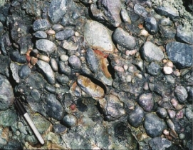
A) rounded
B) angular
A) rounded
B) angular
سؤال
What is the oldest unit or feature in this figure? 
A) 1
B) 2
C) 3
D) 4
E) there is no way to tell
A) 1
B) 2
C) 3
D) 4
E) there is no way to tell
سؤال
سؤال
Which locations are composed of loose materials not bedrock)? 
A) 1 and 2
B) 2 and 3
C) 3 and 4
D) 1 and 3
E) 2 and 4
A) 1 and 2
B) 2 and 3
C) 3 and 4
D) 1 and 3
E) 2 and 4
سؤال
سؤال
What are some components of the landscape shown in this photograph? 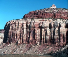
A) a natural stain on the outside of the rocks
B) fractures and layers
C) loose rocks covering a slope-forming unit
D) rounding of the upper parts of the cliff
E) all of these
A) a natural stain on the outside of the rocks
B) fractures and layers
C) loose rocks covering a slope-forming unit
D) rounding of the upper parts of the cliff
E) all of these
سؤال
Which locations) have loose, angular rocks? 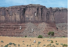
A) 1
B) 2
C) 3
D) 4
E) 1 and 2
A) 1
B) 2
C) 3
D) 4
E) 1 and 2
سؤال
The sediment in this photograph mostly likely formed in: 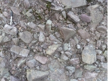
A) a steep mountain front
B) a river
C) a sand dune
D) deep water conditions on the seafloor
A) a steep mountain front
B) a river
C) a sand dune
D) deep water conditions on the seafloor
سؤال
The rock in this photograph mostly likely formed in: 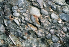
A) a steep mountain front
B) a river
C) a sand dune
D) deep water conditions on the seafloor
A) a steep mountain front
B) a river
C) a sand dune
D) deep water conditions on the seafloor
سؤال
سؤال
سؤال
What is the oldest unit or feature in this figure? 
A) 1
B) 2
C) 3
D) 4
E) 5
A) 1
B) 2
C) 3
D) 4
E) 5
سؤال
Which locations contain rocks that are in place part of the bedrock)? 
A) 1 and 2
B) 2 and 3
C) 3 and 4
D) 1 and 3
E) 2 and 4
A) 1 and 2
B) 2 and 3
C) 3 and 4
D) 1 and 3
E) 2 and 4
سؤال
The sediment in this photograph most likely formed in: 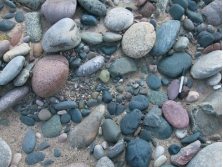
A) a steep mountain front
B) a river
C) a sand dune
D) deep water conditions on the seafloor
A) a steep mountain front
B) a river
C) a sand dune
D) deep water conditions on the seafloor
سؤال
The vertical black lines indicated in rock units #3 and #4 indicate what type of feature? 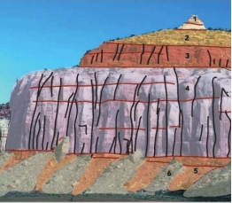
A) fractures
B) beddings
C) slopes
D) loose rock
A) fractures
B) beddings
C) slopes
D) loose rock
سؤال
سؤال
Which locations consist of sediment rather than sedimentary rocks? 
A) 1 and 2
B) 2 and 3
C) 3 and 4
D) 1 and 3
E) 2, 3, and 4
A) 1 and 2
B) 2 and 3
C) 3 and 4
D) 1 and 3
E) 2, 3, and 4
سؤال
سؤال
سؤال
سؤال
What is the best criterion for the relative ages of the rocks in this photograph? 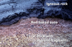
A) The igneous rock is younger because it is on top.
B) The igneous rock is younger because it has baked the adjacent rock.
C) The lower rock is younger because it contains pieces of volcanic rock.
D) The igneous rock is older because it formed at depth.
A) The igneous rock is younger because it is on top.
B) The igneous rock is younger because it has baked the adjacent rock.
C) The lower rock is younger because it contains pieces of volcanic rock.
D) The igneous rock is older because it formed at depth.
سؤال
The feature shown is a smaller, steep-sided mountain and has had its edges eroded away. This feature would commonly be called a: 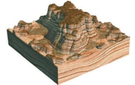
A) butte
B) mesa
C) knob
A) butte
B) mesa
C) knob
سؤال
The oldest unit or feature in this photograph is: 
A) the rock at the top that contains angular fragments
B) the gray layer in the middle of the photograph
C) the tilted rocks at the bottom
D) there is no way to tell
A) the rock at the top that contains angular fragments
B) the gray layer in the middle of the photograph
C) the tilted rocks at the bottom
D) there is no way to tell
سؤال
The youngest unit or feature in this photograph is: 
A) the rock at the top that contains angular fragments
B) the gray layer in the middle of the photograph
C) the tilted rocks at the bottom
D) there is no way to tell
A) the rock at the top that contains angular fragments
B) the gray layer in the middle of the photograph
C) the tilted rocks at the bottom
D) there is no way to tell
سؤال
The image represents a broad, flat-topped mountain with steep sides. This feature is called a: 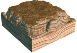
A) mesa
B) butte
C) knob
A) mesa
B) butte
C) knob
سؤال
سؤال
What is the youngest unit or feature in this figure? 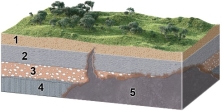
A) 1
B) 2
C) 3
D) 4
E) 5
A) 1
B) 2
C) 3
D) 4
E) 5
سؤال
What order did the rock layers and features form in this photograph listed from oldest to youngest)? 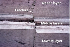
A) upper layer, fracture, middle layers, lowest layer
B) lowest layer, middle layers, fracture, upper layer
C) lower layer, middle layers, upper layer, fracture
D) none of these
A) upper layer, fracture, middle layers, lowest layer
B) lowest layer, middle layers, fracture, upper layer
C) lower layer, middle layers, upper layer, fracture
D) none of these
سؤال
سؤال
What can you interpret about the relative age of the rocks and features in this photograph? 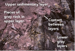
A) The upper sedimentary layer is younger.
B) The lower gray layers are younger.
C) The layers are the same age because the boundary is so irregular.
D) It is not possible to tell the relative ages of the layers.
A) The upper sedimentary layer is younger.
B) The lower gray layers are younger.
C) The layers are the same age because the boundary is so irregular.
D) It is not possible to tell the relative ages of the layers.
سؤال
Which of the following are valid criteria for inferring the relative ages of the two rock types in this photograph? 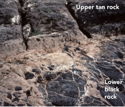
A) The black rock is younger because it is on the bottom.
B) The tan rock is younger because it contains pieces of the black rock.
C) The black rock is younger because it is crosscut by the tan rock.
D) The evidence is contradictory about the relative ages of these two rocks.
A) The black rock is younger because it is on the bottom.
B) The tan rock is younger because it contains pieces of the black rock.
C) The black rock is younger because it is crosscut by the tan rock.
D) The evidence is contradictory about the relative ages of these two rocks.
سؤال
سؤال
What sort of environment would possibly deposit sediment like that seen in the image? 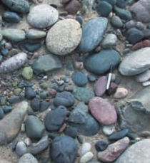
A) river channels
B) floodplain
C) steep mountain slope
D) cliff face
A) river channels
B) floodplain
C) steep mountain slope
D) cliff face
سؤال
What can you interpret about the relative ages of the rocks and features in this photograph? 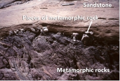
A) The sandstone is older because it is lighter in color.
B) The metamorphic rock is older because it is rougher from longer weathering.
C) The metamorphic rock is older because pieces of it are in the sandstone.
D) The sandstone is older because it is on top.
A) The sandstone is older because it is lighter in color.
B) The metamorphic rock is older because it is rougher from longer weathering.
C) The metamorphic rock is older because pieces of it are in the sandstone.
D) The sandstone is older because it is on top.
سؤال
سؤال
سؤال
سؤال
سؤال
سؤال
سؤال
سؤال
سؤال
سؤال
What type of map is shown here? 
A) shaded-relief map
B) topographic map with contours
C) satellite image
D) geologic map
A) shaded-relief map
B) topographic map with contours
C) satellite image
D) geologic map
سؤال
Which letter on the accompanying figure indicates the amount of topographic relief? 
A) A
B) B
C) C
D) D
A) A
B) B
C) C
D) D
سؤال
سؤال
سؤال
Which letter on the accompanying figure indicates depth? 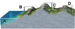
A) A
B) B
C) C
D) D
A) A
B) B
C) C
D) D
سؤال
سؤال
سؤال
سؤال
What type of map is shown here? 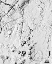
A) shaded-relief map
B) topographic map with contours
C) satellite image
D) geologic map
A) shaded-relief map
B) topographic map with contours
C) satellite image
D) geologic map
سؤال
سؤال
Which letter on the accompanying figure indicates the elevation? 
A) A
B) B
C) C
D) D
A) A
B) B
C) C
D) D
سؤال
سؤال
This image would be best used in what situation? 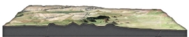
A) A petroleum company wants to know if any geologic structures in the area could contain oil pools.
B) The thickness of the surface layer of rock needs to be determined for a construction site.
C) The average gradient for a particular area needs to be known to study surface runoff.
A) A petroleum company wants to know if any geologic structures in the area could contain oil pools.
B) The thickness of the surface layer of rock needs to be determined for a construction site.
C) The average gradient for a particular area needs to be known to study surface runoff.
سؤال
سؤال
This figure shows the main subdivisions of the geologic timescale. Which of these is the Paleozoic? 
A) A
B) B
C) C
D) D
A) A
B) B
C) C
D) D
سؤال
سؤال
سؤال
سؤال
سؤال
سؤال
This figure shows three blocks in water. Which two materials have the same density? 
A) blocks 1 and 2
B) blocks 2 and 3
C) block 1 and 3
D) block 2 and the water 4
E) block 3 and the water 4
A) blocks 1 and 2
B) blocks 2 and 3
C) block 1 and 3
D) block 2 and the water 4
E) block 3 and the water 4
سؤال
Which of the following may be interpreted from the sketch? 
A) A fault has cut through the rock layers.
B) The fault is younger than all the rock layers present.
C) The oldest environment represented may have been a river channel, based upon the shape of the clasts.
D) All of these.
A) A fault has cut through the rock layers.
B) The fault is younger than all the rock layers present.
C) The oldest environment represented may have been a river channel, based upon the shape of the clasts.
D) All of these.
سؤال
سؤال
This figure shows the main subdivisions of the geologic timescale. Which of these is the Cenozoic? 
A) A
B) B
C) C
D) D
A) A
B) B
C) C
D) D
سؤال
سؤال
What may be interpreted from this sketch? 
A) The basalt is younger than the fault.
B) The tan silt layer is likely the oldest layer present.
C) None of these.
A) The basalt is younger than the fault.
B) The tan silt layer is likely the oldest layer present.
C) None of these.
سؤال
سؤال
سؤال
This figure shows the main subdivisions of the geologic timescale. Which of these is the Mesozoic? 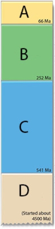
A) A
B) B
C) C
D) D
A) A
B) B
C) C
D) D
سؤال
سؤال
This figure shows three blocks in water. Which of these materials is the densest? 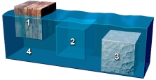
A) block 1
B) block 2
C) block 3
D) the water
A) block 1
B) block 2
C) block 3
D) the water
سؤال
سؤال
سؤال
This figure shows three blocks in water. Which of these materials is the least dense? 
A) block 1
B) block 2
C) block 3
D) the water 4
A) block 1
B) block 2
C) block 3
D) the water 4

فتح الحزمة
قم بالتسجيل لفتح البطاقات في هذه المجموعة!
Unlock Deck
Unlock Deck
1/106
العب
ملء الشاشة (f)
Deck 2: Investigating Geologic Questions
1
Which of the following is NOT a recommended strategy for observing a landscape?
A) Observe the entire landscape first and then focus on smaller parts, one part at a time.
B) Examine complexities of each feature rather than grouping features into types.
C) Focus on one type of feature at a time, noting where this type of feature is present.
D) Examine relationships between different features.
B
2
This indicates to us that the environment in which this rock formed was likely:
A) a river channel
B) a steep mountain front
A) a river channel
B) a steep mountain front
A
3
What is the youngest unit or feature in this figure?
A) 1
B) 2
C) 3
D) 4
E) there is no way to tell
A) 1
B) 2
C) 3
D) 4
E) there is no way to tell
D
4
What shape are the pebble-sized particles that make up the rock?
A) rounded
B) angular
A) rounded
B) angular
فتح الحزمة
افتح القفل للوصول البطاقات البالغ عددها 106 في هذه المجموعة.
فتح الحزمة
k this deck
5
What is the oldest unit or feature in this figure?
A) 1
B) 2
C) 3
D) 4
E) there is no way to tell
A) 1
B) 2
C) 3
D) 4
E) there is no way to tell
فتح الحزمة
افتح القفل للوصول البطاقات البالغ عددها 106 في هذه المجموعة.
فتح الحزمة
k this deck
6
Rocks that are easy to erode often create:
A) slopes
B) ledges
C) cliffs
A) slopes
B) ledges
C) cliffs
فتح الحزمة
افتح القفل للوصول البطاقات البالغ عددها 106 في هذه المجموعة.
فتح الحزمة
k this deck
7
Which locations are composed of loose materials not bedrock)?
A) 1 and 2
B) 2 and 3
C) 3 and 4
D) 1 and 3
E) 2 and 4
A) 1 and 2
B) 2 and 3
C) 3 and 4
D) 1 and 3
E) 2 and 4
فتح الحزمة
افتح القفل للوصول البطاقات البالغ عددها 106 في هذه المجموعة.
فتح الحزمة
k this deck
8
What was the main mystery described for the Mediterranean Sea?
A) A volcanic eruption destroyed the ancient city of Alexandria.
B) A meteorite formed the western Mediterranean Sea.
C) The Mediterranean dried up and deposited layers of salt.
D) A large landmass collapsed downward, forming the sea.
A) A volcanic eruption destroyed the ancient city of Alexandria.
B) A meteorite formed the western Mediterranean Sea.
C) The Mediterranean dried up and deposited layers of salt.
D) A large landmass collapsed downward, forming the sea.
فتح الحزمة
افتح القفل للوصول البطاقات البالغ عددها 106 في هذه المجموعة.
فتح الحزمة
k this deck
9
What are some components of the landscape shown in this photograph?
A) a natural stain on the outside of the rocks
B) fractures and layers
C) loose rocks covering a slope-forming unit
D) rounding of the upper parts of the cliff
E) all of these
A) a natural stain on the outside of the rocks
B) fractures and layers
C) loose rocks covering a slope-forming unit
D) rounding of the upper parts of the cliff
E) all of these
فتح الحزمة
افتح القفل للوصول البطاقات البالغ عددها 106 في هذه المجموعة.
فتح الحزمة
k this deck
10
Which locations) have loose, angular rocks?
A) 1
B) 2
C) 3
D) 4
E) 1 and 2
A) 1
B) 2
C) 3
D) 4
E) 1 and 2
فتح الحزمة
افتح القفل للوصول البطاقات البالغ عددها 106 في هذه المجموعة.
فتح الحزمة
k this deck
11
The sediment in this photograph mostly likely formed in:
A) a steep mountain front
B) a river
C) a sand dune
D) deep water conditions on the seafloor
A) a steep mountain front
B) a river
C) a sand dune
D) deep water conditions on the seafloor
فتح الحزمة
افتح القفل للوصول البطاقات البالغ عددها 106 في هذه المجموعة.
فتح الحزمة
k this deck
12
The rock in this photograph mostly likely formed in:
A) a steep mountain front
B) a river
C) a sand dune
D) deep water conditions on the seafloor
A) a steep mountain front
B) a river
C) a sand dune
D) deep water conditions on the seafloor
فتح الحزمة
افتح القفل للوصول البطاقات البالغ عددها 106 في هذه المجموعة.
فتح الحزمة
k this deck
13
Rocks that are more resistant to erosion are more likely to create:
A) cliffs
B) slopes
C) ledges
A) cliffs
B) slopes
C) ledges
فتح الحزمة
افتح القفل للوصول البطاقات البالغ عددها 106 في هذه المجموعة.
فتح الحزمة
k this deck
14
Beneath the Mediterranean Sea, large deposits of salt and layers of wind-deposited sand dating from around 6 million years ago are present. Which of the following would you conclude based upon this information?
A) The Mediterranean Sea once evaporated, leaving behind large salt deposits and creating a desert-like environment of wind-blown sands
B) The Mediterranean Sea was once deeper than at present, depositing large amounts of salt and layered sand
C) The environment within the Mediterranean Sea has not changed from 6 million years ago to today.
D) Sand and salt have blown into the Mediterranean Sea from the surrounding desert areas
فتح الحزمة
افتح القفل للوصول البطاقات البالغ عددها 106 في هذه المجموعة.
فتح الحزمة
k this deck
15
What is the oldest unit or feature in this figure?
A) 1
B) 2
C) 3
D) 4
E) 5
A) 1
B) 2
C) 3
D) 4
E) 5
فتح الحزمة
افتح القفل للوصول البطاقات البالغ عددها 106 في هذه المجموعة.
فتح الحزمة
k this deck
16
Which locations contain rocks that are in place part of the bedrock)?
A) 1 and 2
B) 2 and 3
C) 3 and 4
D) 1 and 3
E) 2 and 4
A) 1 and 2
B) 2 and 3
C) 3 and 4
D) 1 and 3
E) 2 and 4
فتح الحزمة
افتح القفل للوصول البطاقات البالغ عددها 106 في هذه المجموعة.
فتح الحزمة
k this deck
17
The sediment in this photograph most likely formed in:
A) a steep mountain front
B) a river
C) a sand dune
D) deep water conditions on the seafloor
A) a steep mountain front
B) a river
C) a sand dune
D) deep water conditions on the seafloor
فتح الحزمة
افتح القفل للوصول البطاقات البالغ عددها 106 في هذه المجموعة.
فتح الحزمة
k this deck
18
The vertical black lines indicated in rock units #3 and #4 indicate what type of feature?
A) fractures
B) beddings
C) slopes
D) loose rock
A) fractures
B) beddings
C) slopes
D) loose rock
فتح الحزمة
افتح القفل للوصول البطاقات البالغ عددها 106 في هذه المجموعة.
فتح الحزمة
k this deck
19
The Mediterranean Sea is connected with the Atlantic Ocean through the:
A) Strait of Gibraltar
B) Red Sea
C) Nile River
D) Black Sea
A) Strait of Gibraltar
B) Red Sea
C) Nile River
D) Black Sea
فتح الحزمة
افتح القفل للوصول البطاقات البالغ عددها 106 في هذه المجموعة.
فتح الحزمة
k this deck
20
Which locations consist of sediment rather than sedimentary rocks?
A) 1 and 2
B) 2 and 3
C) 3 and 4
D) 1 and 3
E) 2, 3, and 4
A) 1 and 2
B) 2 and 3
C) 3 and 4
D) 1 and 3
E) 2, 3, and 4
فتح الحزمة
افتح القفل للوصول البطاقات البالغ عددها 106 في هذه المجموعة.
فتح الحزمة
k this deck
21
What kind of map gives detailed information regarding the elevation of the land's surface?
A) topographic
B) shaded relief
C) geologic
D) satellite image
A) topographic
B) shaded relief
C) geologic
D) satellite image
فتح الحزمة
افتح القفل للوصول البطاقات البالغ عددها 106 في هذه المجموعة.
فتح الحزمة
k this deck
22
What strategy was described for inferring the environment in which a rock formed?
A) smashing the rock into pieces to see whether it breaks into square or rounded pieces
B) comparing the characteristics of the rock to deposits from modern environments
C) imagining what would happen if the rock was metamorphosed
D) all of these
A) smashing the rock into pieces to see whether it breaks into square or rounded pieces
B) comparing the characteristics of the rock to deposits from modern environments
C) imagining what would happen if the rock was metamorphosed
D) all of these
فتح الحزمة
افتح القفل للوصول البطاقات البالغ عددها 106 في هذه المجموعة.
فتح الحزمة
k this deck
23
Which of the following is a principle to interpret relative ages?
A) The youngest rock is on the bottom.
B) A geologic feature is older than any rock or feature it crosscuts.
C) A younger rock can include pieces of an older rock.
D) An older magma can bake or metamorphose younger rocks.
A) The youngest rock is on the bottom.
B) A geologic feature is older than any rock or feature it crosscuts.
C) A younger rock can include pieces of an older rock.
D) An older magma can bake or metamorphose younger rocks.
فتح الحزمة
افتح القفل للوصول البطاقات البالغ عددها 106 في هذه المجموعة.
فتح الحزمة
k this deck
24
What is the best criterion for the relative ages of the rocks in this photograph?
A) The igneous rock is younger because it is on top.
B) The igneous rock is younger because it has baked the adjacent rock.
C) The lower rock is younger because it contains pieces of volcanic rock.
D) The igneous rock is older because it formed at depth.
A) The igneous rock is younger because it is on top.
B) The igneous rock is younger because it has baked the adjacent rock.
C) The lower rock is younger because it contains pieces of volcanic rock.
D) The igneous rock is older because it formed at depth.
فتح الحزمة
افتح القفل للوصول البطاقات البالغ عددها 106 في هذه المجموعة.
فتح الحزمة
k this deck
25
The feature shown is a smaller, steep-sided mountain and has had its edges eroded away. This feature would commonly be called a:
A) butte
B) mesa
C) knob
A) butte
B) mesa
C) knob
فتح الحزمة
افتح القفل للوصول البطاقات البالغ عددها 106 في هذه المجموعة.
فتح الحزمة
k this deck
26
The oldest unit or feature in this photograph is:
A) the rock at the top that contains angular fragments
B) the gray layer in the middle of the photograph
C) the tilted rocks at the bottom
D) there is no way to tell
A) the rock at the top that contains angular fragments
B) the gray layer in the middle of the photograph
C) the tilted rocks at the bottom
D) there is no way to tell
فتح الحزمة
افتح القفل للوصول البطاقات البالغ عددها 106 في هذه المجموعة.
فتح الحزمة
k this deck
27
The youngest unit or feature in this photograph is:
A) the rock at the top that contains angular fragments
B) the gray layer in the middle of the photograph
C) the tilted rocks at the bottom
D) there is no way to tell
A) the rock at the top that contains angular fragments
B) the gray layer in the middle of the photograph
C) the tilted rocks at the bottom
D) there is no way to tell
فتح الحزمة
افتح القفل للوصول البطاقات البالغ عددها 106 في هذه المجموعة.
فتح الحزمة
k this deck
28
The image represents a broad, flat-topped mountain with steep sides. This feature is called a:
A) mesa
B) butte
C) knob
A) mesa
B) butte
C) knob
فتح الحزمة
افتح القفل للوصول البطاقات البالغ عددها 106 في هذه المجموعة.
فتح الحزمة
k this deck
29
When a fracture cuts across several rock layers, we can interpret that:
A) the fracture is younger than the layers it crosscuts
B) the fracture is older than the layers it crosscuts
C) the layers of rock are younger than the fracture.
D) the fracture formed at some time prior to the rock layers
A) the fracture is younger than the layers it crosscuts
B) the fracture is older than the layers it crosscuts
C) the layers of rock are younger than the fracture.
D) the fracture formed at some time prior to the rock layers
فتح الحزمة
افتح القفل للوصول البطاقات البالغ عددها 106 في هذه المجموعة.
فتح الحزمة
k this deck
30
What is the youngest unit or feature in this figure?
A) 1
B) 2
C) 3
D) 4
E) 5
A) 1
B) 2
C) 3
D) 4
E) 5
فتح الحزمة
افتح القفل للوصول البطاقات البالغ عددها 106 في هذه المجموعة.
فتح الحزمة
k this deck
31
What order did the rock layers and features form in this photograph listed from oldest to youngest)?
A) upper layer, fracture, middle layers, lowest layer
B) lowest layer, middle layers, fracture, upper layer
C) lower layer, middle layers, upper layer, fracture
D) none of these
A) upper layer, fracture, middle layers, lowest layer
B) lowest layer, middle layers, fracture, upper layer
C) lower layer, middle layers, upper layer, fracture
D) none of these
فتح الحزمة
افتح القفل للوصول البطاقات البالغ عددها 106 في هذه المجموعة.
فتح الحزمة
k this deck
32
The age of a fossil, organism, rock, geologic feature, or event as defined relative to other geologic features or events is the:
A) relative age
B) absolute age
C) numerical age
D) radiometric age
A) relative age
B) absolute age
C) numerical age
D) radiometric age
فتح الحزمة
افتح القفل للوصول البطاقات البالغ عددها 106 في هذه المجموعة.
فتح الحزمة
k this deck
33
What can you interpret about the relative age of the rocks and features in this photograph?
A) The upper sedimentary layer is younger.
B) The lower gray layers are younger.
C) The layers are the same age because the boundary is so irregular.
D) It is not possible to tell the relative ages of the layers.
A) The upper sedimentary layer is younger.
B) The lower gray layers are younger.
C) The layers are the same age because the boundary is so irregular.
D) It is not possible to tell the relative ages of the layers.
فتح الحزمة
افتح القفل للوصول البطاقات البالغ عددها 106 في هذه المجموعة.
فتح الحزمة
k this deck
34
Which of the following are valid criteria for inferring the relative ages of the two rock types in this photograph?
A) The black rock is younger because it is on the bottom.
B) The tan rock is younger because it contains pieces of the black rock.
C) The black rock is younger because it is crosscut by the tan rock.
D) The evidence is contradictory about the relative ages of these two rocks.
A) The black rock is younger because it is on the bottom.
B) The tan rock is younger because it contains pieces of the black rock.
C) The black rock is younger because it is crosscut by the tan rock.
D) The evidence is contradictory about the relative ages of these two rocks.
فتح الحزمة
افتح القفل للوصول البطاقات البالغ عددها 106 في هذه المجموعة.
فتح الحزمة
k this deck
35
The phrase trading location for time signifies that:
A) It takes more time to observe a landscape than is available.
B) Expensive homes are built in locations that cost people time.
C) Different parts of a landscape can be used to infer how the landscape changes over time.
D) Some rocks are harder than others to erode and so last a longer time.
A) It takes more time to observe a landscape than is available.
B) Expensive homes are built in locations that cost people time.
C) Different parts of a landscape can be used to infer how the landscape changes over time.
D) Some rocks are harder than others to erode and so last a longer time.
فتح الحزمة
افتح القفل للوصول البطاقات البالغ عددها 106 في هذه المجموعة.
فتح الحزمة
k this deck
36
What sort of environment would possibly deposit sediment like that seen in the image?
A) river channels
B) floodplain
C) steep mountain slope
D) cliff face
A) river channels
B) floodplain
C) steep mountain slope
D) cliff face
فتح الحزمة
افتح القفل للوصول البطاقات البالغ عددها 106 في هذه المجموعة.
فتح الحزمة
k this deck
37
What can you interpret about the relative ages of the rocks and features in this photograph?
A) The sandstone is older because it is lighter in color.
B) The metamorphic rock is older because it is rougher from longer weathering.
C) The metamorphic rock is older because pieces of it are in the sandstone.
D) The sandstone is older because it is on top.
A) The sandstone is older because it is lighter in color.
B) The metamorphic rock is older because it is rougher from longer weathering.
C) The metamorphic rock is older because pieces of it are in the sandstone.
D) The sandstone is older because it is on top.
فتح الحزمة
افتح القفل للوصول البطاقات البالغ عددها 106 في هذه المجموعة.
فتح الحزمة
k this deck
38
What map is best for showing detailed geologic information about an area?
A) topographic
B) shaded relief
C) geologic
D) satellite image
A) topographic
B) shaded relief
C) geologic
D) satellite image
فتح الحزمة
افتح القفل للوصول البطاقات البالغ عددها 106 في هذه المجموعة.
فتح الحزمة
k this deck
39
Over time, when a mesa becomes a butte and a butte eventually becomes hills and knobs, we can infer what physical process has taken place:
A) erosion
B) glaciations
C) river transportation
D) deposition
A) erosion
B) glaciations
C) river transportation
D) deposition
فتح الحزمة
افتح القفل للوصول البطاقات البالغ عددها 106 في هذه المجموعة.
فتح الحزمة
k this deck
40
What interpretation can be made from an igneous rock body such as granite) that has baked or metamorphosed the adjacent rocks?
A) When the granite was molten, the heat from the magma altered the preexisting rocks around it.
B) The adjacent rocks reacted with the solid granite to create a zone of metamorphism.
A) When the granite was molten, the heat from the magma altered the preexisting rocks around it.
B) The adjacent rocks reacted with the solid granite to create a zone of metamorphism.
فتح الحزمة
افتح القفل للوصول البطاقات البالغ عددها 106 في هذه المجموعة.
فتح الحزمة
k this deck
41
What does the type of evolutionary diagrams discussed in the textbook show?
A) how one creature evolved into another creature
B) changing of fossils up through a stratigraphic section
C) evolution of the ways topographic maps have been drawn during history
D) the sequence of events that deposited the rocks and formed the landscape
A) how one creature evolved into another creature
B) changing of fossils up through a stratigraphic section
C) evolution of the ways topographic maps have been drawn during history
D) the sequence of events that deposited the rocks and formed the landscape
فتح الحزمة
افتح القفل للوصول البطاقات البالغ عددها 106 في هذه المجموعة.
فتح الحزمة
k this deck
42
What specific type of image uses measurements of different wavelengths of light reflecting from a land surface to create a computer-processed image to show the distribution of different types of plants, rocks, and other features?
A) satellite images
B) geologic map
C) topographic map
D) shaded relief map
A) satellite images
B) geologic map
C) topographic map
D) shaded relief map
فتح الحزمة
افتح القفل للوصول البطاقات البالغ عددها 106 في هذه المجموعة.
فتح الحزمة
k this deck
43
Elevation variations in the land's surface might best be represented by an):
A) topographic profile
B) geologic map
C) outcrop
A) topographic profile
B) geologic map
C) outcrop
فتح الحزمة
افتح القفل للوصول البطاقات البالغ عددها 106 في هذه المجموعة.
فتح الحزمة
k this deck
44
Which type of map or diagram would best indicate elevation of the land surface?
A) shaded-relief map
B) satellite image
C) topographic map
D) stratigraphic section
A) shaded-relief map
B) satellite image
C) topographic map
D) stratigraphic section
فتح الحزمة
افتح القفل للوصول البطاقات البالغ عددها 106 في هذه المجموعة.
فتح الحزمة
k this deck
45
Which of the following could be associated with a steep slope?
A) a mountain side
B) a cliff
C) closely spaced contour lines
D) all of these
A) a mountain side
B) a cliff
C) closely spaced contour lines
D) all of these
فتح الحزمة
افتح القفل للوصول البطاقات البالغ عددها 106 في هذه المجموعة.
فتح الحزمة
k this deck
46
What type of map depicts the shape of the land surface by showing the elevation of the land surface with a series of lines called contours?
A) topographic map
B) satellite image
C) shaded relief map
D) geologic map
A) topographic map
B) satellite image
C) shaded relief map
D) geologic map
فتح الحزمة
افتح القفل للوصول البطاقات البالغ عددها 106 في هذه المجموعة.
فتح الحزمة
k this deck
47
What type of map is shown here?
A) shaded-relief map
B) topographic map with contours
C) satellite image
D) geologic map
A) shaded-relief map
B) topographic map with contours
C) satellite image
D) geologic map
فتح الحزمة
افتح القفل للوصول البطاقات البالغ عددها 106 في هذه المجموعة.
فتح الحزمة
k this deck
48
Which letter on the accompanying figure indicates the amount of topographic relief?
A) A
B) B
C) C
D) D
A) A
B) B
C) C
D) D
فتح الحزمة
افتح القفل للوصول البطاقات البالغ عددها 106 في هذه المجموعة.
فتح الحزمة
k this deck
49
What type of figure would you use to portray the relative thicknesses of rock units stacked on top of one another?
A) shaded relief map
B) topographic map
C) satellite image
D) stratigraphic section
E) evolutionary diagram
A) shaded relief map
B) topographic map
C) satellite image
D) stratigraphic section
E) evolutionary diagram
فتح الحزمة
افتح القفل للوصول البطاقات البالغ عددها 106 في هذه المجموعة.
فتح الحزمة
k this deck
50
Which of the following map or diagram would best show you the shape of the land surface?
A) shaded-relief map
B) satellite image
C) geologic map
D) stratigraphic section
A) shaded-relief map
B) satellite image
C) geologic map
D) stratigraphic section
فتح الحزمة
افتح القفل للوصول البطاقات البالغ عددها 106 في هذه المجموعة.
فتح الحزمة
k this deck
51
Which letter on the accompanying figure indicates depth?
A) A
B) B
C) C
D) D
A) A
B) B
C) C
D) D
فتح الحزمة
افتح القفل للوصول البطاقات البالغ عددها 106 في هذه المجموعة.
فتح الحزمة
k this deck
52
Slopes that drop or rise sharply in elevation are:
A) steep
B) plains
C) contours
A) steep
B) plains
C) contours
فتح الحزمة
افتح القفل للوصول البطاقات البالغ عددها 106 في هذه المجموعة.
فتح الحزمة
k this deck
53
Topographic maps often have some contour lines that are darker than other contour lines. These darker lines are called:
A) index contours
B) contour intervals
A) index contours
B) contour intervals
فتح الحزمة
افتح القفل للوصول البطاقات البالغ عددها 106 في هذه المجموعة.
فتح الحزمة
k this deck
54
What type of map is used primarily to show the shape of the land by simulating light and dark shading on the hills and valleys?
A) shaded relief map
B) satellite image
C) geologic map
D) topographic map
A) shaded relief map
B) satellite image
C) geologic map
D) topographic map
فتح الحزمة
افتح القفل للوصول البطاقات البالغ عددها 106 في هذه المجموعة.
فتح الحزمة
k this deck
55
What type of map is shown here?
A) shaded-relief map
B) topographic map with contours
C) satellite image
D) geologic map
A) shaded-relief map
B) topographic map with contours
C) satellite image
D) geologic map
فتح الحزمة
افتح القفل للوصول البطاقات البالغ عددها 106 في هذه المجموعة.
فتح الحزمة
k this deck
56
Slopes in flatter areas are:
A) gentle
B) elevated
C) cliffs
D) indexes
A) gentle
B) elevated
C) cliffs
D) indexes
فتح الحزمة
افتح القفل للوصول البطاقات البالغ عددها 106 في هذه المجموعة.
فتح الحزمة
k this deck
57
Which letter on the accompanying figure indicates the elevation?
A) A
B) B
C) C
D) D
A) A
B) B
C) C
D) D
فتح الحزمة
افتح القفل للوصول البطاقات البالغ عددها 106 في هذه المجموعة.
فتح الحزمة
k this deck
58
If you wanted to determine how deep a rock layer was below a particular point on the surface, what type of figure would be most useful?
A) shaded relief map
B) topographic map
C) satellite image
D) evolutionary diagram
E) geologic cross section
A) shaded relief map
B) topographic map
C) satellite image
D) evolutionary diagram
E) geologic cross section
فتح الحزمة
افتح القفل للوصول البطاقات البالغ عددها 106 في هذه المجموعة.
فتح الحزمة
k this deck
59
This image would be best used in what situation?
A) A petroleum company wants to know if any geologic structures in the area could contain oil pools.
B) The thickness of the surface layer of rock needs to be determined for a construction site.
C) The average gradient for a particular area needs to be known to study surface runoff.
A) A petroleum company wants to know if any geologic structures in the area could contain oil pools.
B) The thickness of the surface layer of rock needs to be determined for a construction site.
C) The average gradient for a particular area needs to be known to study surface runoff.
فتح الحزمة
افتح القفل للوصول البطاقات البالغ عددها 106 في هذه المجموعة.
فتح الحزمة
k this deck
60
What specific type of map represents the distribution of rock units and geologic features exposed on the surface?
A) geologic map
B) topographic map
C) contour map
D) shaded relief map
A) geologic map
B) topographic map
C) contour map
D) shaded relief map
فتح الحزمة
افتح القفل للوصول البطاقات البالغ عددها 106 في هذه المجموعة.
فتح الحزمة
k this deck
61
This figure shows the main subdivisions of the geologic timescale. Which of these is the Paleozoic?
A) A
B) B
C) C
D) D
A) A
B) B
C) C
D) D
فتح الحزمة
افتح القفل للوصول البطاقات البالغ عددها 106 في هذه المجموعة.
فتح الحزمة
k this deck
62
Which of the following are ways in which a geologist may determine the density of earth materials?
A) determining the weight of the object, but not its volume
B) calculating the volume of the object, but not its mass
C) none of these
A) determining the weight of the object, but not its volume
B) calculating the volume of the object, but not its mass
C) none of these
فتح الحزمة
افتح القفل للوصول البطاقات البالغ عددها 106 في هذه المجموعة.
فتح الحزمة
k this deck
63
If a runner races 50 meters in 5 seconds, how fast is she going?
A) 1 meter per second
B) 5 meters per second
C) 10 meters per second
D) 50 meters per second
E) none of these
A) 1 meter per second
B) 5 meters per second
C) 10 meters per second
D) 50 meters per second
E) none of these
فتح الحزمة
افتح القفل للوصول البطاقات البالغ عددها 106 في هذه المجموعة.
فتح الحزمة
k this deck
64
Which of the following is an example of quantitative data?
A) Augustine volcano represents a dangerous situation
B) the rocks were dark gray and angular
C) the steam coming from the mountain was dark gray in color
D) the rocks were too hot to touch
E) none of these
A) Augustine volcano represents a dangerous situation
B) the rocks were dark gray and angular
C) the steam coming from the mountain was dark gray in color
D) the rocks were too hot to touch
E) none of these
فتح الحزمة
افتح القفل للوصول البطاقات البالغ عددها 106 في هذه المجموعة.
فتح الحزمة
k this deck
65
Which of the following is an example of quantitative data?
A) North America is moving across Earth's surface several centimeters per year
B) the river has flooded a low-lying area
C) the volcano is releasing much steam
D) volcanoes are dangerous
E) when held, one rock feels heavier than another rock
A) North America is moving across Earth's surface several centimeters per year
B) the river has flooded a low-lying area
C) the volcano is releasing much steam
D) volcanoes are dangerous
E) when held, one rock feels heavier than another rock
فتح الحزمة
افتح القفل للوصول البطاقات البالغ عددها 106 في هذه المجموعة.
فتح الحزمة
k this deck
66
Qualitative data may involve which of the following?
A) labels
B) sketches
C) descriptive words
D) images
E) all of these
A) labels
B) sketches
C) descriptive words
D) images
E) all of these
فتح الحزمة
افتح القفل للوصول البطاقات البالغ عددها 106 في هذه المجموعة.
فتح الحزمة
k this deck
67
This figure shows three blocks in water. Which two materials have the same density?
A) blocks 1 and 2
B) blocks 2 and 3
C) block 1 and 3
D) block 2 and the water 4
E) block 3 and the water 4
A) blocks 1 and 2
B) blocks 2 and 3
C) block 1 and 3
D) block 2 and the water 4
E) block 3 and the water 4
فتح الحزمة
افتح القفل للوصول البطاقات البالغ عددها 106 في هذه المجموعة.
فتح الحزمة
k this deck
68
Which of the following may be interpreted from the sketch?
A) A fault has cut through the rock layers.
B) The fault is younger than all the rock layers present.
C) The oldest environment represented may have been a river channel, based upon the shape of the clasts.
D) All of these.
A) A fault has cut through the rock layers.
B) The fault is younger than all the rock layers present.
C) The oldest environment represented may have been a river channel, based upon the shape of the clasts.
D) All of these.
فتح الحزمة
افتح القفل للوصول البطاقات البالغ عددها 106 في هذه المجموعة.
فتح الحزمة
k this deck
69
Which of the following are true for an evolutionary diagram?
A) Uses a sequence of geologic diagrams to depict the geologic history of an area.
B) May use block diagrams, cross sections, or maps.
C) Shows the progression of changes an area undergoes through time.
D) All of these.
A) Uses a sequence of geologic diagrams to depict the geologic history of an area.
B) May use block diagrams, cross sections, or maps.
C) Shows the progression of changes an area undergoes through time.
D) All of these.
فتح الحزمة
افتح القفل للوصول البطاقات البالغ عددها 106 في هذه المجموعة.
فتح الحزمة
k this deck
70
This figure shows the main subdivisions of the geologic timescale. Which of these is the Cenozoic?
A) A
B) B
C) C
D) D
A) A
B) B
C) C
D) D
فتح الحزمة
افتح القفل للوصول البطاقات البالغ عددها 106 في هذه المجموعة.
فتح الحزمة
k this deck
71
The formula to determine density is:
A) mass/volume
B) mass/weight
C) volume/mass
D) gravity/mass
E) weight/gravity
A) mass/volume
B) mass/weight
C) volume/mass
D) gravity/mass
E) weight/gravity
فتح الحزمة
افتح القفل للوصول البطاقات البالغ عددها 106 في هذه المجموعة.
فتح الحزمة
k this deck
72
What may be interpreted from this sketch?
A) The basalt is younger than the fault.
B) The tan silt layer is likely the oldest layer present.
C) None of these.
A) The basalt is younger than the fault.
B) The tan silt layer is likely the oldest layer present.
C) None of these.
فتح الحزمة
افتح القفل للوصول البطاقات البالغ عددها 106 في هذه المجموعة.
فتح الحزمة
k this deck
73
If a description of sediment states that it contains large, angular fragments that are mostly red in color, what type of data would this represent?
A) qualitative
B) quantitative
C) numerical
D) measurement
A) qualitative
B) quantitative
C) numerical
D) measurement
فتح الحزمة
افتح القفل للوصول البطاقات البالغ عددها 106 في هذه المجموعة.
فتح الحزمة
k this deck
74
A geologist performs analyses on a rock to gather data recording its specific chemical composition. This type of data is:
A) quantitative
B) qualitative
C) a survey
A) quantitative
B) qualitative
C) a survey
فتح الحزمة
افتح القفل للوصول البطاقات البالغ عددها 106 في هذه المجموعة.
فتح الحزمة
k this deck
75
This figure shows the main subdivisions of the geologic timescale. Which of these is the Mesozoic?
A) A
B) B
C) C
D) D
A) A
B) B
C) C
D) D
فتح الحزمة
افتح القفل للوصول البطاقات البالغ عددها 106 في هذه المجموعة.
فتح الحزمة
k this deck
76
Quantitative data may include:
A) Specific temperature data
B) Size measurements of sediments
C) Chemistry of water in a stream
D) Age of a rock
E) All of these
A) Specific temperature data
B) Size measurements of sediments
C) Chemistry of water in a stream
D) Age of a rock
E) All of these
فتح الحزمة
افتح القفل للوصول البطاقات البالغ عددها 106 في هذه المجموعة.
فتح الحزمة
k this deck
77
This figure shows three blocks in water. Which of these materials is the densest?
A) block 1
B) block 2
C) block 3
D) the water
A) block 1
B) block 2
C) block 3
D) the water
فتح الحزمة
افتح القفل للوصول البطاقات البالغ عددها 106 في هذه المجموعة.
فتح الحزمة
k this deck
78
Which of the following are ways in which a geologist may determine the density of earth materials?
A) through direct measurement in the laboratory
B) by measuring the different velocities of seismic waves
C) using instruments to measure the pull of gravity
D) all of these
A) through direct measurement in the laboratory
B) by measuring the different velocities of seismic waves
C) using instruments to measure the pull of gravity
D) all of these
فتح الحزمة
افتح القفل للوصول البطاقات البالغ عددها 106 في هذه المجموعة.
فتح الحزمة
k this deck
79
Which of the following is true about density and weight?
A) density is higher if you have a larger volume of the same material
B) density is lower if you have a larger volume of the same material
C) a substance is more dense at night than during the day
D) weight depends on the mass of the object and the pull of gravity
E) none of these
A) density is higher if you have a larger volume of the same material
B) density is lower if you have a larger volume of the same material
C) a substance is more dense at night than during the day
D) weight depends on the mass of the object and the pull of gravity
E) none of these
فتح الحزمة
افتح القفل للوصول البطاقات البالغ عددها 106 في هذه المجموعة.
فتح الحزمة
k this deck
80
This figure shows three blocks in water. Which of these materials is the least dense?
A) block 1
B) block 2
C) block 3
D) the water 4
A) block 1
B) block 2
C) block 3
D) the water 4
فتح الحزمة
افتح القفل للوصول البطاقات البالغ عددها 106 في هذه المجموعة.
فتح الحزمة
k this deck
فتح الحزمة
افتح القفل للوصول البطاقات البالغ عددها 106 في هذه المجموعة.


