Deck 16: Streams and Flooding
ملء الشاشة (f)
سؤال
What three factors of a drainage basin influence the flow response to rainfall? 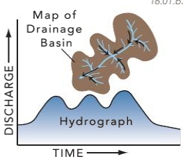
A) slope
B) size
C) shape
D) all of these
A) slope
B) size
C) shape
D) all of these
سؤال
Compared with curve 2 on this hydrograph, what is a possible explanation for curve 1? 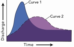
A) the basin for curve 1 has steeper slopes than the basin for curve 2
B) the storm recorded by curve 1 was shorter and more intense than the storm represented by curve 2
C) curve 1 shows the same area as curve 2 but after urbanization
D) all of these are possible
A) the basin for curve 1 has steeper slopes than the basin for curve 2
B) the storm recorded by curve 1 was shorter and more intense than the storm represented by curve 2
C) curve 1 shows the same area as curve 2 but after urbanization
D) all of these are possible
سؤال
Based on the accompanying hydrograph, what was the stream discharge when the data period shown in the graph ended? 
A) 1.8 meters per second
B) 4 meters per second
C) 4 cubic meters per second
D) 9 cubic meters per second
E) 10 cubic meters per second
A) 1.8 meters per second
B) 4 meters per second
C) 4 cubic meters per second
D) 9 cubic meters per second
E) 10 cubic meters per second
سؤال
سؤال
What units of measure would most likely be represented by letters A-E on the bottom of the accompanying hydrograph? 
A) meters
B) hours
C) kilograms
D) miles
A) meters
B) hours
C) kilograms
D) miles
سؤال
What is the mostly likely setting for this drainage pattern? 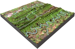
A) the rocks have a relatively equal resistance to erosion
B) drainages have followed a series of fractures that branch off of one another
C) the area has folded or faulted rocks with different resistances to erosion
D) a volcano once existed here but has been partly eroded away
A) the rocks have a relatively equal resistance to erosion
B) drainages have followed a series of fractures that branch off of one another
C) the area has folded or faulted rocks with different resistances to erosion
D) a volcano once existed here but has been partly eroded away
سؤال
What is the mostly likely setting for this drainage pattern? 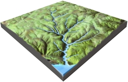
A) the rocks have a relatively equal resistance to erosion
B) drainages have followed a series of fractures that branch off of one another
C) the area has folded or faulted rocks with different resistances to erosion
D) a volcano once existed here but has been partly eroded away
A) the rocks have a relatively equal resistance to erosion
B) drainages have followed a series of fractures that branch off of one another
C) the area has folded or faulted rocks with different resistances to erosion
D) a volcano once existed here but has been partly eroded away
سؤال
What is a reasonable interpretation for the flow event recorded by this hydrograph? 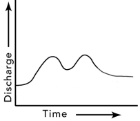
A) there were two pulses of runoff because there were two storms
B) the drainage basin has several distinct parts
C) one pulse could be due to snowmelt and the other to rain
D) all of these
A) there were two pulses of runoff because there were two storms
B) the drainage basin has several distinct parts
C) one pulse could be due to snowmelt and the other to rain
D) all of these
سؤال
سؤال
سؤال
سؤال
سؤال
سؤال
Which event is best represented by the hydrograph shown here? 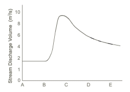
A) a summer thunderstorm
B) a very long period of steady light rain
C) a long drought with no rain for months
D) a winter snowstorm followed by very cold weather
A) a summer thunderstorm
B) a very long period of steady light rain
C) a long drought with no rain for months
D) a winter snowstorm followed by very cold weather
سؤال
سؤال
سؤال
سؤال
سؤال
سؤال
What is the pattern of discharge shown by this hydrograph? 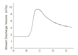
A) discharge gradually increases and quickly decreases
B) discharge quickly increases and gradually decreases
C) discharge gradually decreases and quickly increases
D) discharges quickly decreases and gradually increases
A) discharge gradually increases and quickly decreases
B) discharge quickly increases and gradually decreases
C) discharge gradually decreases and quickly increases
D) discharges quickly decreases and gradually increases
سؤال
سؤال
Deposition in bedrock channels occurs along river banks and behind obstacles as: 
A) water velocity decreases
B) water velocity increases
C) the gradient increases
A) water velocity decreases
B) water velocity increases
C) the gradient increases
سؤال
What happens to a river as it flows through a delta and encounters the sea? 
A) the discharge and water velocity increase
B) the maximum sediment grain size carried by the river increases
C) the total sediment load carried by the river decreases
D) all of these
A) the discharge and water velocity increase
B) the maximum sediment grain size carried by the river increases
C) the total sediment load carried by the river decreases
D) all of these
سؤال
سؤال
سؤال
سؤال
سؤال
سؤال
On this graph of discharge versus season for a river in the Rocky Mountains, why is the highest runoff likely to be in the spring? 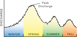
A) winter snow melts in the spring
B) the Rocky Mountains have many tornadoes during the spring
C) the Rocky Mountains experience hurricanes in the spring
D) all of these
A) winter snow melts in the spring
B) the Rocky Mountains have many tornadoes during the spring
C) the Rocky Mountains experience hurricanes in the spring
D) all of these
سؤال
Which of the following graphs is typical for the profile of a river? 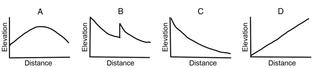
A) A
B) B
C) C
D) D
A) A
B) B
C) C
D) D
سؤال
سؤال
What typically happens when tributaries join the main river? 
A) channel size increases
B) water velocity increases
C) the amount of discharge increases
D) total sediment load increases
E) all of these
A) channel size increases
B) water velocity increases
C) the amount of discharge increases
D) total sediment load increases
E) all of these
سؤال
What does the associated graph indicate about a stream? 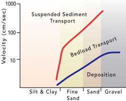
A) Silt and clay are carried in suspension under most stream velocities.
B) Sand and gravel are deposited at low velocities but transported at higher velocities.
C) Sand is carried in suspension only at high velocities.
D) As fast-moving water slows down, fine sand can switch from transport by suspension to the bed load.
E) All of these.
سؤال
سؤال
What happens to water velocity downstream? It generally: 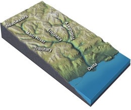
A) Decreases
B) remains the same
C) increases
D) there is no way to tell because discharge cannot be determined
A) Decreases
B) remains the same
C) increases
D) there is no way to tell because discharge cannot be determined
سؤال
سؤال
سؤال
سؤال
سؤال
سؤال
سؤال
What could cause this stream to begin carving into the landscape? 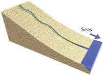
A) if base level is lowered, such as a drop in sea level
B) if the land is uplifted relative to the sea
C) if a change in climate weathers and weakens the rocks
D) all of these
A) if base level is lowered, such as a drop in sea level
B) if the land is uplifted relative to the sea
C) if a change in climate weathers and weakens the rocks
D) all of these
سؤال
Use the following information to calculate the gradient of River X. If the vertical change is 10 meters in 1 kilometer, then the gradient expressed in m/km is: 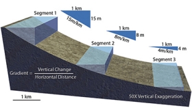
A) 1
B) 10
C) 100
A) 1
B) 10
C) 100
سؤال
سؤال
سؤال
The profile of a stream is steeper at its: 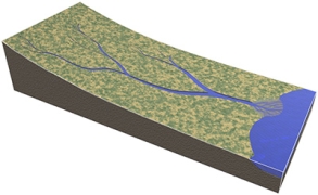
A) headwaters
B) mouth
C) capacity level
D) delta
A) headwaters
B) mouth
C) capacity level
D) delta
سؤال
سؤال
The gradient of the stream between the two ends on the accompanying figure is: 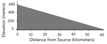
A) 1 meter per kilometer
B) 10 meters per kilometer
C) 100 meters per kilometer
D) 1 to 1
E) 6 to 1
A) 1 meter per kilometer
B) 10 meters per kilometer
C) 100 meters per kilometer
D) 1 to 1
E) 6 to 1
سؤال
سؤال
سؤال
سؤال
سؤال
سؤال
What could cause a canyon to be deeper upstream than downstream? 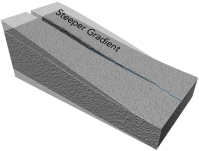
A) the area upstream could be uplifted more than areas downstream
B) the area upstream is higher above base level and so results in deep erosion
C) a steeper gradient allows more erosion upstream
D) all of these
A) the area upstream could be uplifted more than areas downstream
B) the area upstream is higher above base level and so results in deep erosion
C) a steeper gradient allows more erosion upstream
D) all of these
سؤال
What could cause this stream to deposit sediment? 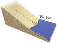
A) a rise in base level, such as a rise in sea level
B) subsidence of the land, producing slopes that are less steep
C) both a rise in base level or subsidence of the land
D) none of these
A) a rise in base level, such as a rise in sea level
B) subsidence of the land, producing slopes that are less steep
C) both a rise in base level or subsidence of the land
D) none of these
سؤال
سؤال
سؤال
سؤال
سؤال
سؤال
At which site along this stream would a cutbank form? 
A) A
B) B
C) C
D) D
A) A
B) B
C) C
D) D
سؤال
سؤال
At which sites would this stream profile most likely be located? 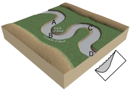
A) A and C
B) B and D
C) C and D
D) D and A
A) A and C
B) B and D
C) C and D
D) D and A
سؤال
سؤال
Where would be the relatively safest place to build a bridge across the stream in the accompanying figure? 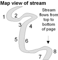
A) between points 1 and 2
B) between points 3 and 4
C) between points 5 and 6
D) between points 7 and 8
A) between points 1 and 2
B) between points 3 and 4
C) between points 5 and 6
D) between points 7 and 8
سؤال
سؤال
سؤال
سؤال
Which of the lettered sites would most likely be undercut by migration of a meander? 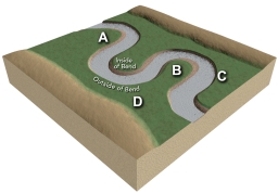
A) A
B) B
C) C
D) D
A) A
B) B
C) C
D) D
سؤال
سؤال
Which of the following profiles does NOT match its position on the stream? 
A) A
B) B
C) C
D) D
A) A
B) B
C) C
D) D
سؤال
At which site along this stream would a point bar form? 
A) A
B) B
C) C
D) D
A) A
B) B
C) C
D) D
سؤال
سؤال
سؤال
سؤال
سؤال
سؤال
Which site along this stream would have the highest velocity for that segment of the stream? 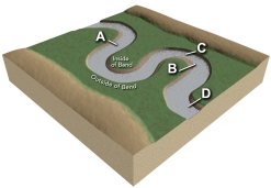
A) A
B) B
C) C
D) D
A) A
B) B
C) C
D) D
سؤال
سؤال

فتح الحزمة
قم بالتسجيل لفتح البطاقات في هذه المجموعة!
Unlock Deck
Unlock Deck
1/137
العب
ملء الشاشة (f)
Deck 16: Streams and Flooding
1
What three factors of a drainage basin influence the flow response to rainfall?
A) slope
B) size
C) shape
D) all of these
A) slope
B) size
C) shape
D) all of these
D
2
Compared with curve 2 on this hydrograph, what is a possible explanation for curve 1?
A) the basin for curve 1 has steeper slopes than the basin for curve 2
B) the storm recorded by curve 1 was shorter and more intense than the storm represented by curve 2
C) curve 1 shows the same area as curve 2 but after urbanization
D) all of these are possible
A) the basin for curve 1 has steeper slopes than the basin for curve 2
B) the storm recorded by curve 1 was shorter and more intense than the storm represented by curve 2
C) curve 1 shows the same area as curve 2 but after urbanization
D) all of these are possible
D
3
Based on the accompanying hydrograph, what was the stream discharge when the data period shown in the graph ended?
A) 1.8 meters per second
B) 4 meters per second
C) 4 cubic meters per second
D) 9 cubic meters per second
E) 10 cubic meters per second
A) 1.8 meters per second
B) 4 meters per second
C) 4 cubic meters per second
D) 9 cubic meters per second
E) 10 cubic meters per second
C
4
A delta forms when:
A) ocean waves, especially during storms, pile up sediment along the coast
B) a steep mountain front collapses sending sediment out into the sea
C) a river slows and deposits sediment as it enters a lake or sea
D) windblown dust slides down steep hillsides and into a lake
A) ocean waves, especially during storms, pile up sediment along the coast
B) a steep mountain front collapses sending sediment out into the sea
C) a river slows and deposits sediment as it enters a lake or sea
D) windblown dust slides down steep hillsides and into a lake
فتح الحزمة
افتح القفل للوصول البطاقات البالغ عددها 137 في هذه المجموعة.
فتح الحزمة
k this deck
5
What units of measure would most likely be represented by letters A-E on the bottom of the accompanying hydrograph?
A) meters
B) hours
C) kilograms
D) miles
A) meters
B) hours
C) kilograms
D) miles
فتح الحزمة
افتح القفل للوصول البطاقات البالغ عددها 137 في هذه المجموعة.
فتح الحزمة
k this deck
6
What is the mostly likely setting for this drainage pattern?
A) the rocks have a relatively equal resistance to erosion
B) drainages have followed a series of fractures that branch off of one another
C) the area has folded or faulted rocks with different resistances to erosion
D) a volcano once existed here but has been partly eroded away
A) the rocks have a relatively equal resistance to erosion
B) drainages have followed a series of fractures that branch off of one another
C) the area has folded or faulted rocks with different resistances to erosion
D) a volcano once existed here but has been partly eroded away
فتح الحزمة
افتح القفل للوصول البطاقات البالغ عددها 137 في هذه المجموعة.
فتح الحزمة
k this deck
7
What is the mostly likely setting for this drainage pattern?
A) the rocks have a relatively equal resistance to erosion
B) drainages have followed a series of fractures that branch off of one another
C) the area has folded or faulted rocks with different resistances to erosion
D) a volcano once existed here but has been partly eroded away
A) the rocks have a relatively equal resistance to erosion
B) drainages have followed a series of fractures that branch off of one another
C) the area has folded or faulted rocks with different resistances to erosion
D) a volcano once existed here but has been partly eroded away
فتح الحزمة
افتح القفل للوصول البطاقات البالغ عددها 137 في هذه المجموعة.
فتح الحزمة
k this deck
8
What is a reasonable interpretation for the flow event recorded by this hydrograph?
A) there were two pulses of runoff because there were two storms
B) the drainage basin has several distinct parts
C) one pulse could be due to snowmelt and the other to rain
D) all of these
A) there were two pulses of runoff because there were two storms
B) the drainage basin has several distinct parts
C) one pulse could be due to snowmelt and the other to rain
D) all of these
فتح الحزمة
افتح القفل للوصول البطاقات البالغ عددها 137 في هذه المجموعة.
فتح الحزمة
k this deck
9
Soluble materials in flowing water can be removed and transported by a process called:
A) dissolution
B) tumbling
C) saltation
D) gravity
A) dissolution
B) tumbling
C) saltation
D) gravity
فتح الحزمة
افتح القفل للوصول البطاقات البالغ عددها 137 في هذه المجموعة.
فتح الحزمة
k this deck
10
What is formed when a river meets the sea and slows down and deposits its load of sediments?
A) a delta
B) a beach
C) meanders
A) a delta
B) a beach
C) meanders
فتح الحزمة
افتح القفل للوصول البطاقات البالغ عددها 137 في هذه المجموعة.
فتح الحزمة
k this deck
11
What is a drainage divide?
A) A ridge or strip of high ground separating one drainage basin from another
B) The area where a stream flows into a lake or ocean
C) The total area drained by a stream and its tributaries
D) The arrangement of a stream and its tributaries
A) A ridge or strip of high ground separating one drainage basin from another
B) The area where a stream flows into a lake or ocean
C) The total area drained by a stream and its tributaries
D) The arrangement of a stream and its tributaries
فتح الحزمة
افتح القفل للوصول البطاقات البالغ عددها 137 في هذه المجموعة.
فتح الحزمة
k this deck
12
Smaller subsidiary channels that feed main channels of rivers are called:
A) tributaries
B) drainage systems
C) drainage patterns
A) tributaries
B) drainage systems
C) drainage patterns
فتح الحزمة
افتح القفل للوصول البطاقات البالغ عددها 137 في هذه المجموعة.
فتح الحزمة
k this deck
13
The amount of water flowing through a channel over a given amount of time is called its:
A) discharge
B) rate of flow
C) velocity
D) drainage basin
A) discharge
B) rate of flow
C) velocity
D) drainage basin
فتح الحزمة
افتح القفل للوصول البطاقات البالغ عددها 137 في هذه المجموعة.
فتح الحزمة
k this deck
14
Which event is best represented by the hydrograph shown here?
A) a summer thunderstorm
B) a very long period of steady light rain
C) a long drought with no rain for months
D) a winter snowstorm followed by very cold weather
A) a summer thunderstorm
B) a very long period of steady light rain
C) a long drought with no rain for months
D) a winter snowstorm followed by very cold weather
فتح الحزمة
افتح القفل للوصول البطاقات البالغ عددها 137 في هذه المجموعة.
فتح الحزمة
k this deck
15
The force behind a river's flow is:
A) gravity
B) its sediment load
C) the shape of the river bed
D) its velocity
A) gravity
B) its sediment load
C) the shape of the river bed
D) its velocity
فتح الحزمة
افتح القفل للوصول البطاقات البالغ عددها 137 في هذه المجموعة.
فتح الحزمة
k this deck
16
The size of clasts that a stream can carry is primarily controlled by:
A) the water temperature
B) the dissolved and suspended load of a stream
C) how close the stream is to the ocean
D) the velocity and turbulence of the current
E) whether it is a permanent or ephemeral stream
A) the water temperature
B) the dissolved and suspended load of a stream
C) how close the stream is to the ocean
D) the velocity and turbulence of the current
E) whether it is a permanent or ephemeral stream
فتح الحزمة
افتح القفل للوصول البطاقات البالغ عددها 137 في هذه المجموعة.
فتح الحزمة
k this deck
17
A hydrograph shows:
A) the change in a river's discharge over time
B) the beginning and ending elevations of a river
C) the change in the sediment load of a river
D) the length and width of a river
A) the change in a river's discharge over time
B) the beginning and ending elevations of a river
C) the change in the sediment load of a river
D) the length and width of a river
فتح الحزمة
افتح القفل للوصول البطاقات البالغ عددها 137 في هذه المجموعة.
فتح الحزمة
k this deck
18
If erosion and deposition occur at the same rate, how can we best describe the particles of sediment on a streambed?
A) only very small particles will be present along the stream bottom
B) particles neither move in, nor move out of this part of the stream
C) as the sediment moves downstream, it is replaced by a similar volume of sediment
D) pebbles and cobbles carried away are replaced by the same number of smaller particles
فتح الحزمة
افتح القفل للوصول البطاقات البالغ عددها 137 في هذه المجموعة.
فتح الحزمة
k this deck
19
Which of the following is true about how a stream erodes material?
A) abrasion is concentrated on the upstream side of obstructions
B) turbulence of the water is less important than the temperature, which affects viscosity
C) erosion occurs equally on two sides of a bend
D) water cannot erode unless it is carrying sediment
E) all of these
A) abrasion is concentrated on the upstream side of obstructions
B) turbulence of the water is less important than the temperature, which affects viscosity
C) erosion occurs equally on two sides of a bend
D) water cannot erode unless it is carrying sediment
E) all of these
فتح الحزمة
افتح القفل للوصول البطاقات البالغ عددها 137 في هذه المجموعة.
فتح الحزمة
k this deck
20
What is the pattern of discharge shown by this hydrograph?
A) discharge gradually increases and quickly decreases
B) discharge quickly increases and gradually decreases
C) discharge gradually decreases and quickly increases
D) discharges quickly decreases and gradually increases
A) discharge gradually increases and quickly decreases
B) discharge quickly increases and gradually decreases
C) discharge gradually decreases and quickly increases
D) discharges quickly decreases and gradually increases
فتح الحزمة
افتح القفل للوصول البطاقات البالغ عددها 137 في هذه المجموعة.
فتح الحزمة
k this deck
21
Bedrock and sediment in a stream is most susceptible to erosion if it is:
A) in slow-moving water in an eddy
B) in a site that is sheltered from oncoming clasts
C) located in a turbulent part of the river
D) composed entirely of large clasts that affect stream flow
E) all of these
A) in slow-moving water in an eddy
B) in a site that is sheltered from oncoming clasts
C) located in a turbulent part of the river
D) composed entirely of large clasts that affect stream flow
E) all of these
فتح الحزمة
افتح القفل للوصول البطاقات البالغ عددها 137 في هذه المجموعة.
فتح الحزمة
k this deck
22
Deposition in bedrock channels occurs along river banks and behind obstacles as:
A) water velocity decreases
B) water velocity increases
C) the gradient increases
A) water velocity decreases
B) water velocity increases
C) the gradient increases
فتح الحزمة
افتح القفل للوصول البطاقات البالغ عددها 137 في هذه المجموعة.
فتح الحزمة
k this deck
23
What happens to a river as it flows through a delta and encounters the sea?
A) the discharge and water velocity increase
B) the maximum sediment grain size carried by the river increases
C) the total sediment load carried by the river decreases
D) all of these
A) the discharge and water velocity increase
B) the maximum sediment grain size carried by the river increases
C) the total sediment load carried by the river decreases
D) all of these
فتح الحزمة
افتح القفل للوصول البطاقات البالغ عددها 137 في هذه المجموعة.
فتح الحزمة
k this deck
24
Which of the following does NOT influence whether sediment is picked up by a stream?
A) size and density of the sediment
B) turbulence of the moving water
C) location of the sediment in the stream
D) whether the stream flows north-south or east-west
A) size and density of the sediment
B) turbulence of the moving water
C) location of the sediment in the stream
D) whether the stream flows north-south or east-west
فتح الحزمة
افتح القفل للوصول البطاقات البالغ عددها 137 في هذه المجموعة.
فتح الحزمة
k this deck
25
In mountain streams that are steep with high stream velocities, which pattern of erosion is the most common?
A) Channel bed is eroded faster than the channel sides
B) Channel sides are eroded faster than channel bed
C) Channel bed and channel sides are eroded equally
A) Channel bed is eroded faster than the channel sides
B) Channel sides are eroded faster than channel bed
C) Channel bed and channel sides are eroded equally
فتح الحزمة
افتح القفل للوصول البطاقات البالغ عددها 137 في هذه المجموعة.
فتح الحزمة
k this deck
26
Potholes or bowl-shaped pits are formed when flowing water and sediments swirl in small:
A) depressions
B) holes
C) pits
D) all of these
A) depressions
B) holes
C) pits
D) all of these
فتح الحزمة
افتح القفل للوصول البطاقات البالغ عددها 137 في هذه المجموعة.
فتح الحزمة
k this deck
27
Which particles of sediment are most likely to be transported as suspended load?
A) small, low density particles
B) pebbles of average density
C) sand and gravel of relatively high density
D) dissolved ions in solution
E) all of these
A) small, low density particles
B) pebbles of average density
C) sand and gravel of relatively high density
D) dissolved ions in solution
E) all of these
فتح الحزمة
افتح القفل للوصول البطاقات البالغ عددها 137 في هذه المجموعة.
فتح الحزمة
k this deck
28
Which of the following is true about transport of sediment in a stream?
A) Pebbles and cobbles are mostly transported by suspension.
B) Sediment that is deposited within a stream bed is unlikely to be transported again.
C) Sand can be transported in a series of bounces along the stream bed.
D) Slower current can carry larger clasts because the water is in contact with each clast for a longer time.
E) Sand grains are converted into salt by the process of saltation.
فتح الحزمة
افتح القفل للوصول البطاقات البالغ عددها 137 في هذه المجموعة.
فتح الحزمة
k this deck
29
On this graph of discharge versus season for a river in the Rocky Mountains, why is the highest runoff likely to be in the spring?
A) winter snow melts in the spring
B) the Rocky Mountains have many tornadoes during the spring
C) the Rocky Mountains experience hurricanes in the spring
D) all of these
A) winter snow melts in the spring
B) the Rocky Mountains have many tornadoes during the spring
C) the Rocky Mountains experience hurricanes in the spring
D) all of these
فتح الحزمة
افتح القفل للوصول البطاقات البالغ عددها 137 في هذه المجموعة.
فتح الحزمة
k this deck
30
Which of the following graphs is typical for the profile of a river?
A) A
B) B
C) C
D) D
A) A
B) B
C) C
D) D
فتح الحزمة
افتح القفل للوصول البطاقات البالغ عددها 137 في هذه المجموعة.
فتح الحزمة
k this deck
31
What is the type of stream transportation by a series of short leaps or bounces off the bottom of the streambed?
A) saltation
B) traction
C) abrasion
D) suspended load
A) saltation
B) traction
C) abrasion
D) suspended load
فتح الحزمة
افتح القفل للوصول البطاقات البالغ عددها 137 في هذه المجموعة.
فتح الحزمة
k this deck
32
What typically happens when tributaries join the main river?
A) channel size increases
B) water velocity increases
C) the amount of discharge increases
D) total sediment load increases
E) all of these
A) channel size increases
B) water velocity increases
C) the amount of discharge increases
D) total sediment load increases
E) all of these
فتح الحزمة
افتح القفل للوصول البطاقات البالغ عددها 137 في هذه المجموعة.
فتح الحزمة
k this deck
33
What does the associated graph indicate about a stream?
A) Silt and clay are carried in suspension under most stream velocities.
B) Sand and gravel are deposited at low velocities but transported at higher velocities.
C) Sand is carried in suspension only at high velocities.
D) As fast-moving water slows down, fine sand can switch from transport by suspension to the bed load.
E) All of these.
فتح الحزمة
افتح القفل للوصول البطاقات البالغ عددها 137 في هذه المجموعة.
فتح الحزمة
k this deck
34
Which of the following is a condition favoring deposition of sediment?
A) an increase in water velocity
B) a decrease in gradient of the stream
C) an increase in turbulence of the water
D) an increase in the salt content of the water
E) a decrease in grain size as a clast breaks into two pieces
A) an increase in water velocity
B) a decrease in gradient of the stream
C) an increase in turbulence of the water
D) an increase in the salt content of the water
E) a decrease in grain size as a clast breaks into two pieces
فتح الحزمة
افتح القفل للوصول البطاقات البالغ عددها 137 في هذه المجموعة.
فتح الحزمة
k this deck
35
What happens to water velocity downstream? It generally:
A) Decreases
B) remains the same
C) increases
D) there is no way to tell because discharge cannot be determined
A) Decreases
B) remains the same
C) increases
D) there is no way to tell because discharge cannot be determined
فتح الحزمة
افتح القفل للوصول البطاقات البالغ عددها 137 في هذه المجموعة.
فتح الحزمة
k this deck
36
The amount of sediment carried by a stream is the:
A) sediment load
B) suspended load
C) saltation load
D) traction load
A) sediment load
B) suspended load
C) saltation load
D) traction load
فتح الحزمة
افتح القفل للوصول البطاقات البالغ عددها 137 في هذه المجموعة.
فتح الحزمة
k this deck
37
Which of the following is the correct relationship between stream velocity and sediment load?
A) As velocity increases, so does the stream's capacity to carry a larger load.
B) As velocity increases, the amount of sediment carried by the stream decreases.
C) There is no definite relationship between velocity and sediment load.
A) As velocity increases, so does the stream's capacity to carry a larger load.
B) As velocity increases, the amount of sediment carried by the stream decreases.
C) There is no definite relationship between velocity and sediment load.
فتح الحزمة
افتح القفل للوصول البطاقات البالغ عددها 137 في هذه المجموعة.
فتح الحزمة
k this deck
38
What happens to the erosive power of a stream as velocity increases?
A) Erosion increases.
B) Erosion decreases
C) Erosion is not related to velocity.
A) Erosion increases.
B) Erosion decreases
C) Erosion is not related to velocity.
فتح الحزمة
افتح القفل للوصول البطاقات البالغ عددها 137 في هذه المجموعة.
فتح الحزمة
k this deck
39
What is the most important geologic agent in eroding, transporting, and depositing sediment?
A) Flowing water
B) Glaciers
C) Wind
D) Ocean waves
A) Flowing water
B) Glaciers
C) Wind
D) Ocean waves
فتح الحزمة
افتح القفل للوصول البطاقات البالغ عددها 137 في هذه المجموعة.
فتح الحزمة
k this deck
40
Which of the following sediment sizes is likely to be transported mostly on the bottom of the stream bed?
A) fine sand
B) sticky clay particles
C) pebbles and cobbles
D) dissolved materials
A) fine sand
B) sticky clay particles
C) pebbles and cobbles
D) dissolved materials
فتح الحزمة
افتح القفل للوصول البطاقات البالغ عددها 137 في هذه المجموعة.
فتح الحزمة
k this deck
41
The area of origin of a river is the:
A) headwater
B) mouth
C) tributary
A) headwater
B) mouth
C) tributary
فتح الحزمة
افتح القفل للوصول البطاقات البالغ عددها 137 في هذه المجموعة.
فتح الحزمة
k this deck
42
What could cause this stream to begin carving into the landscape?
A) if base level is lowered, such as a drop in sea level
B) if the land is uplifted relative to the sea
C) if a change in climate weathers and weakens the rocks
D) all of these
A) if base level is lowered, such as a drop in sea level
B) if the land is uplifted relative to the sea
C) if a change in climate weathers and weakens the rocks
D) all of these
فتح الحزمة
افتح القفل للوصول البطاقات البالغ عددها 137 في هذه المجموعة.
فتح الحزمة
k this deck
43
Use the following information to calculate the gradient of River X. If the vertical change is 10 meters in 1 kilometer, then the gradient expressed in m/km is:
A) 1
B) 10
C) 100
A) 1
B) 10
C) 100
فتح الحزمة
افتح القفل للوصول البطاقات البالغ عددها 137 في هذه المجموعة.
فتح الحزمة
k this deck
44
If a stream drops 15 meters in 15 kilometers, what is its gradient?
A) 100%
B) 1 meter per kilometer
C) 15 meters per kilometer
D) 15 kilometers per meter
E) none of these
A) 100%
B) 1 meter per kilometer
C) 15 meters per kilometer
D) 15 kilometers per meter
E) none of these
فتح الحزمة
افتح القفل للوصول البطاقات البالغ عددها 137 في هذه المجموعة.
فتح الحزمة
k this deck
45
Which of the following is unlikely to cause deposition of sediment along a stream?
A) a decrease in gradient
B) a decrease in water velocity
C) a drop in sea level
D) none of these
A) a decrease in gradient
B) a decrease in water velocity
C) a drop in sea level
D) none of these
فتح الحزمة
افتح القفل للوصول البطاقات البالغ عددها 137 في هذه المجموعة.
فتح الحزمة
k this deck
46
The profile of a stream is steeper at its:
A) headwaters
B) mouth
C) capacity level
D) delta
A) headwaters
B) mouth
C) capacity level
D) delta
فتح الحزمة
افتح القفل للوصول البطاقات البالغ عددها 137 في هذه المجموعة.
فتح الحزمة
k this deck
47
A stream or river that flows all year is referred to as:
A) perennial
B) ephemeral
C) a tributary
A) perennial
B) ephemeral
C) a tributary
فتح الحزمة
افتح القفل للوصول البطاقات البالغ عددها 137 في هذه المجموعة.
فتح الحزمة
k this deck
48
The gradient of the stream between the two ends on the accompanying figure is:
A) 1 meter per kilometer
B) 10 meters per kilometer
C) 100 meters per kilometer
D) 1 to 1
E) 6 to 1
A) 1 meter per kilometer
B) 10 meters per kilometer
C) 100 meters per kilometer
D) 1 to 1
E) 6 to 1
فتح الحزمة
افتح القفل للوصول البطاقات البالغ عددها 137 في هذه المجموعة.
فتح الحزمة
k this deck
49
The cross-sectional area of the channel of a stream or river is calculated by:
A) multiplying the channel's width by its average depth
B) multiplying the channel's depth by its average length
C) dividing the channel's depth by its width
D) adding the channel's width and average length
A) multiplying the channel's width by its average depth
B) multiplying the channel's depth by its average length
C) dividing the channel's depth by its width
D) adding the channel's width and average length
فتح الحزمة
افتح القفل للوصول البطاقات البالغ عددها 137 في هذه المجموعة.
فتح الحزمة
k this deck
50
Which of the following is NOT a common site for deposition of sediment?
A) point bar
B) distributary system
C) levee
D) cutbank
E) floodplain
A) point bar
B) distributary system
C) levee
D) cutbank
E) floodplain
فتح الحزمة
افتح القفل للوصول البطاقات البالغ عددها 137 في هذه المجموعة.
فتح الحزمة
k this deck
51
What does a profile of a river from its headwaters to its mouth typically show?
A) an increase in gradient downstream
B) a straight-line profile reflecting a constant decrease in gradient
C) an abrupt increase followed by a gradual decrease
D) a curved shape that flattens out downstream
E) none of these
A) an increase in gradient downstream
B) a straight-line profile reflecting a constant decrease in gradient
C) an abrupt increase followed by a gradual decrease
D) a curved shape that flattens out downstream
E) none of these
فتح الحزمة
افتح القفل للوصول البطاقات البالغ عددها 137 في هذه المجموعة.
فتح الحزمة
k this deck
52
The volume of water flowing through any part of a river per unit time is calculated by:
A) multiplying the velocity by the cross-sectional area of the river
B) multiplying the velocity times the length of the river
C) dividing the channel's width by its velocity
D) dividing the channel's length by its cross-sectional area
A) multiplying the velocity by the cross-sectional area of the river
B) multiplying the velocity times the length of the river
C) dividing the channel's width by its velocity
D) dividing the channel's length by its cross-sectional area
فتح الحزمة
افتح القفل للوصول البطاقات البالغ عددها 137 في هذه المجموعة.
فتح الحزمة
k this deck
53
Which of the following typically decreases downstream in a river?
A) flow velocity
B) discharge
C) channel size
D) maximum sediment grain size
E) none of these
A) flow velocity
B) discharge
C) channel size
D) maximum sediment grain size
E) none of these
فتح الحزمة
افتح القفل للوصول البطاقات البالغ عددها 137 في هذه المجموعة.
فتح الحزمة
k this deck
54
What could cause a canyon to be deeper upstream than downstream?
A) the area upstream could be uplifted more than areas downstream
B) the area upstream is higher above base level and so results in deep erosion
C) a steeper gradient allows more erosion upstream
D) all of these
A) the area upstream could be uplifted more than areas downstream
B) the area upstream is higher above base level and so results in deep erosion
C) a steeper gradient allows more erosion upstream
D) all of these
فتح الحزمة
افتح القفل للوصول البطاقات البالغ عددها 137 في هذه المجموعة.
فتح الحزمة
k this deck
55
What could cause this stream to deposit sediment?
A) a rise in base level, such as a rise in sea level
B) subsidence of the land, producing slopes that are less steep
C) both a rise in base level or subsidence of the land
D) none of these
A) a rise in base level, such as a rise in sea level
B) subsidence of the land, producing slopes that are less steep
C) both a rise in base level or subsidence of the land
D) none of these
فتح الحزمة
افتح القفل للوصول البطاقات البالغ عددها 137 في هذه المجموعة.
فتح الحزمة
k this deck
56
If a river originates 200 meters above sea level and travels 100 kilometers to the ocean, what is the average gradient in meters per kilometer?
A) 0.2 meters per kilometer
B) 0.5 meters per kilometer
C) 2 meters per kilometer
D) 5 meters per kilometer
E) none of these
A) 0.2 meters per kilometer
B) 0.5 meters per kilometer
C) 2 meters per kilometer
D) 5 meters per kilometer
E) none of these
فتح الحزمة
افتح القفل للوصول البطاقات البالغ عددها 137 في هذه المجموعة.
فتح الحزمة
k this deck
57
Which of the following is true about the base level of a stream:
A) Base level indicates the normal or base) flow level before flooding.
B) The flat top of a mountain is the ultimate base level for most streams.
C) A mountain is close to its base level if bedrock is close to the surface.
D) Most streams have lower gradient close to their base level.
E) Base level generally is near the steepest part of a stream's profile.
فتح الحزمة
افتح القفل للوصول البطاقات البالغ عددها 137 في هذه المجموعة.
فتح الحزمة
k this deck
58
The lowest level to which a stream can erode is its:
A) base level
B) sediment capacity
C) bedrock
D) headwaters
A) base level
B) sediment capacity
C) bedrock
D) headwaters
فتح الحزمة
افتح القفل للوصول البطاقات البالغ عددها 137 في هذه المجموعة.
فتح الحزمة
k this deck
59
The end of the river is the:
A) mouth
B) headwater
C) tributary
A) mouth
B) headwater
C) tributary
فتح الحزمة
افتح القفل للوصول البطاقات البالغ عددها 137 في هذه المجموعة.
فتح الحزمة
k this deck
60
Which of the following can influence a stream's profile?
A) a rise in sea level
B) a fall in sea level
C) tectonics
D) all of these
A) a rise in sea level
B) a fall in sea level
C) tectonics
D) all of these
فتح الحزمة
افتح القفل للوصول البطاقات البالغ عددها 137 في هذه المجموعة.
فتح الحزمة
k this deck
61
At which site along this stream would a cutbank form?
A) A
B) B
C) C
D) D
A) A
B) B
C) C
D) D
فتح الحزمة
افتح القفل للوصول البطاقات البالغ عددها 137 في هذه المجموعة.
فتح الحزمة
k this deck
62
A depositional feature that has been deposited on the inside of a curve because of lower velocity is known as a:
A) point bar
B) midchannel bar
C) meander cutoff
A) point bar
B) midchannel bar
C) meander cutoff
فتح الحزمة
افتح القفل للوصول البطاقات البالغ عددها 137 في هذه المجموعة.
فتح الحزمة
k this deck
63
At which sites would this stream profile most likely be located?
A) A and C
B) B and D
C) C and D
D) D and A
A) A and C
B) B and D
C) C and D
D) D and A
فتح الحزمة
افتح القفل للوصول البطاقات البالغ عددها 137 في هذه المجموعة.
فتح الحزمة
k this deck
64
Which of the following features are generally NOT associated with mountain streams and rivers?
A) waterfalls
B) rapids
C) canyons incised into bedrock
D) meanders
A) waterfalls
B) rapids
C) canyons incised into bedrock
D) meanders
فتح الحزمة
افتح القفل للوصول البطاقات البالغ عددها 137 في هذه المجموعة.
فتح الحزمة
k this deck
65
Where would be the relatively safest place to build a bridge across the stream in the accompanying figure?
A) between points 1 and 2
B) between points 3 and 4
C) between points 5 and 6
D) between points 7 and 8
A) between points 1 and 2
B) between points 3 and 4
C) between points 5 and 6
D) between points 7 and 8
فتح الحزمة
افتح القفل للوصول البطاقات البالغ عددها 137 في هذه المجموعة.
فتح الحزمة
k this deck
66
Which of the following statements about streams is NOT true?
A) base level is the lowest elevation to which a stream can erode
B) a steep stream high above base level generally will be eroding its channel
C) some streams can simply transport material instead of eroding or depositing material
D) streams typically do not respond to a change in climate
A) base level is the lowest elevation to which a stream can erode
B) a steep stream high above base level generally will be eroding its channel
C) some streams can simply transport material instead of eroding or depositing material
D) streams typically do not respond to a change in climate
فتح الحزمة
افتح القفل للوصول البطاقات البالغ عددها 137 في هذه المجموعة.
فتح الحزمة
k this deck
67
If a stream-cut canyon is deep and narrow, which of the following is most likely to be true?
A) rocks in the canyon walls are relatively hard and so easy to erode
B) the stream is probably close to its base level
C) downcutting is occurring faster than widening
D) the stream contains mostly small clasts, such as silt
A) rocks in the canyon walls are relatively hard and so easy to erode
B) the stream is probably close to its base level
C) downcutting is occurring faster than widening
D) the stream contains mostly small clasts, such as silt
فتح الحزمة
افتح القفل للوصول البطاقات البالغ عددها 137 في هذه المجموعة.
فتح الحزمة
k this deck
68
When conditions such as climate remain stable, a stream may approach a dynamic equilibrium state. The stream would then be considered:
A) a graded stream
B) a progressive stream
C) a tributary
A) a graded stream
B) a progressive stream
C) a tributary
فتح الحزمة
افتح القفل للوصول البطاقات البالغ عددها 137 في هذه المجموعة.
فتح الحزمة
k this deck
69
Which of the lettered sites would most likely be undercut by migration of a meander?
A) A
B) B
C) C
D) D
A) A
B) B
C) C
D) D
فتح الحزمة
افتح القفل للوصول البطاقات البالغ عددها 137 في هذه المجموعة.
فتح الحزمة
k this deck
70
How is an alluvial fan formed?
A) a stream erodes down through older terraces and entrenched meanders
B) sediment is deposited by debris flows and streams that decrease in velocity along the mountain front
C) a landslide blocks the stream, causing sediment to accumulate upstream
D) a dam increases the speed of currents below the dam
فتح الحزمة
افتح القفل للوصول البطاقات البالغ عددها 137 في هذه المجموعة.
فتح الحزمة
k this deck
71
Which of the following profiles does NOT match its position on the stream?
A) A
B) B
C) C
D) D
A) A
B) B
C) C
D) D
فتح الحزمة
افتح القفل للوصول البطاقات البالغ عددها 137 في هذه المجموعة.
فتح الحزمة
k this deck
72
At which site along this stream would a point bar form?
A) A
B) B
C) C
D) D
A) A
B) B
C) C
D) D
فتح الحزمة
افتح القفل للوصول البطاقات البالغ عددها 137 في هذه المجموعة.
فتح الحزمة
k this deck
73
Where do mountain streams get most of their load of sediment?
A) landslides, slope failures, and erosion of the mountain sides
B) downward incision into bedrock
C) abrasion of bedrock along the bottom of the channel
D) alluvial fans
A) landslides, slope failures, and erosion of the mountain sides
B) downward incision into bedrock
C) abrasion of bedrock along the bottom of the channel
D) alluvial fans
فتح الحزمة
افتح القفل للوصول البطاقات البالغ عددها 137 في هذه المجموعة.
فتح الحزمة
k this deck
74
Sinuosity refers to:
A) the amount that a river or stream channel curves in a given length
B) the profile of a river or stream in a given length
C) the steepness of a river or stream in a given length
D) the amount of water passing a point in a river or stream in a given length
A) the amount that a river or stream channel curves in a given length
B) the profile of a river or stream in a given length
C) the steepness of a river or stream in a given length
D) the amount of water passing a point in a river or stream in a given length
فتح الحزمة
افتح القفل للوصول البطاقات البالغ عددها 137 في هذه المجموعة.
فتح الحزمة
k this deck
75
What is a point bar?
A) A sandbar deposited along the inside of stream meanders due to lower velocity
B) A new, shorter channel across the narrow neck of a meander
C) A crescent-shaped meander cutoff
D) A flowing network of interconnected rivulets around numerous bars
A) A sandbar deposited along the inside of stream meanders due to lower velocity
B) A new, shorter channel across the narrow neck of a meander
C) A crescent-shaped meander cutoff
D) A flowing network of interconnected rivulets around numerous bars
فتح الحزمة
افتح القفل للوصول البطاقات البالغ عددها 137 في هذه المجموعة.
فتح الحزمة
k this deck
76
Which of the following is true about the formation and migration of meanders?
A) most floodplains do not preserve evidence of the former position of meanders
B) flow velocity is highest when water takes a shortcut around the inside of a bend
C) meanders migrate inward as sediment is deposited on the inside bend
D) migration of meanders back and forth can help form a floodplain
E) none of these
فتح الحزمة
افتح القفل للوصول البطاقات البالغ عددها 137 في هذه المجموعة.
فتح الحزمة
k this deck
77
A stream cannot erode below:
A) sea level
B) its headwaters
C) its channel
D) its bedrock
E) its tributaries
A) sea level
B) its headwaters
C) its channel
D) its bedrock
E) its tributaries
فتح الحزمة
افتح القفل للوصول البطاقات البالغ عددها 137 في هذه المجموعة.
فتح الحزمة
k this deck
78
Which site along this stream would have the highest velocity for that segment of the stream?
A) A
B) B
C) C
D) D
A) A
B) B
C) C
D) D
فتح الحزمة
افتح القفل للوصول البطاقات البالغ عددها 137 في هذه المجموعة.
فتح الحزمة
k this deck
79
When water in a stream or desert wash decreases in velocity, sediment that the stream carries can be deposited in:
A) a delta
B) an alluvial fan
C) a floodplain
D) all of these
A) a delta
B) an alluvial fan
C) a floodplain
D) all of these
فتح الحزمة
افتح القفل للوصول البطاقات البالغ عددها 137 في هذه المجموعة.
فتح الحزمة
k this deck
80
Which of the following is commonly associated with tributaries?
A) rapids when the tributary joins the main river
B) delivery of sediment to the main river
C) an increase in the discharge in the main river
D) all of these
A) rapids when the tributary joins the main river
B) delivery of sediment to the main river
C) an increase in the discharge in the main river
D) all of these
فتح الحزمة
افتح القفل للوصول البطاقات البالغ عددها 137 في هذه المجموعة.
فتح الحزمة
k this deck
فتح الحزمة
افتح القفل للوصول البطاقات البالغ عددها 137 في هذه المجموعة.


